Werdum geodata
Werdum (Lower Saxony) is a seat of a fourth-order administrative division; located in Germany in Europe/Berlin (GMT+2) time zone. With population of 691 people, there are 8356 cities with bigger population in this country. Compared to other cities in Germany, 87.9% of cities are located further ↓South; 82.6% of cities are located further →East and 98.1% of cities have higher elevation than Werdum. Note1


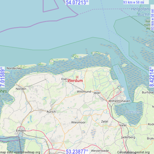
Werdum GPS coordinates[2]
53° 39' 27.036" North, 7° 43' 8.436" East
| Map corner | latitude | longitude |
|---|---|---|
| Upper-left | 54.07213°, | 7.01589° |
| Center: | 53.65751°, | 7.71901° |
| Lower-right: | 53.23877°, | 8.42214° |
| Map W x H: | 92.7×92.7 km | = 57.6×57.6mi |
| max Lat: | 55.01917° ⇑12.1% North |
| Werdum: | 53.65751° |
| min Lat: | ⇓87.9% South 47.40724° |
| min Long | Werdum | max Long |
| 5.92978° | 7.71901° | 14.98853° |
| W 17.4%⇐ | ⇒82.6% E |
Elevation
Elevation of Werdum is 2 m = 7 ft, and this is 247.1 m = 811 ft below average elevation for this country.
| Max E: |
1256 m = 4121 ft | 98.1% |
| Avg. | 249.1 m = 817 ft | |
| Werdum | 2 m = 7 ft | |
Min E: |
-5 m = -16 ft | 1.9% |
See also: Germany elevation on elevation.city.
Geographical zone
Werdum is located in North temperate zone (between Tropic of Cancer and the Arctic Circle). Distance of this North polar circle is 1435 km =891.7 mi to North.| Distance of | km | miles | from Werdum |
|---|---|---|---|
| North Pole | 4040.9 | 2510.9 | to North |
| Arctic Circle | 1435 | 891.7 | to North |
| Tropic Cancer | 3360.2 | 2087.9 | to South |
| Equator | 5966.2 | 3707.2 | to South |


Nearby cities:
15 places around Werdum: (largest is in red/bold)
• Bensersiel
9.4 km =5.8 mi,  280°
280°
• Blomberg
13.9 km =8.6 mi,  229°
229°
• Carolinensiel
6.6 km =4.1 mi,  55°
55°
• Dunum
7.8 km =4.8 mi,  215°
215°
• Esens
7.1 km =4.4 mi,  262°
262°
• Holtgast
10 km =6.2 mi,  252°
252°
• Jever
15 km =9.3 mi,  128°
128°
• Moorweg
9.3 km =5.8 mi, 253°
• Neuharlingersiel
4.8 km =3 mi,  347°
347°
• Ostochtersum
13.9 km =8.6 mi, 245°
• Schweindorf
17.8 km =11.1 mi, 248°
• Spiekeroog
12.6 km =7.8 mi, 352°
• Stedesdorf
4.4 km =2.7 mi, 232°
• Utarp
16.2 km =10.1 mi, 253°
• Wittmund
9.8 km =6.1 mi,  156°
156°
Sources, notices
• [Note1] Compared only with cities in Germany existing in our database
• [Src1] Map data: © OpenStreetMap contributors (CC-BY-SA)
• [Src2] Other city data from geonames.org with taken over terms of usage.
• [Src3] Geographical zone / Annual Mean Temperature by Robert A. Rohde @ Wikipedia
