Münstermaifeld geodata
Münstermaifeld (Rheinland-Pfalz) is a populated place; located in Germany in Europe/Berlin (GMT+2) time zone. With population of 3,435 people, there are 3666 cities with bigger population in this country. Compared to other cities in Germany, 58% of cities are located further ↑North; 89.1% of cities are located further →East and 56% of cities have lower elevation than Münstermaifeld. Note1
Administrative division(s):
- Level 1: Rheinland-Pfalz
- Level 3: Landkreis Mayen-Koblenz
- Level 4: Münstermaifeld


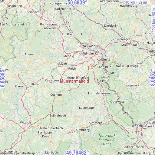
Münstermaifeld GPS coordinates[2]
50° 14' 46.968" North, 7° 21' 43.488" East
| Map corner | latitude | longitude |
|---|---|---|
| Upper-left | 50.6939°, | 6.65895° |
| Center: | 50.24638°, | 7.36208° |
| Lower-right: | 49.79462°, | 8.0652° |
| Map W x H: | 100×100 km | = 62.1×62.1mi |
| max Lat: | 55.01917° ⇑58% North |
| Münstermaifeld: | 50.24638° |
| min Lat: | ⇓42% South 47.40724° |
| min Long | Münstermaifeld | max Long |
| 5.92978° | 7.36208° | 14.98853° |
| W 10.9%⇐ | ⇒89.1% E |
Elevation
Elevation of Münstermaifeld is 266 m = 873 ft, and this is 16.9 m = 55 ft above average elevation for this country.
| Max E: |
1256 m = 4121 ft | 44% |
| Münstermaifeld | 266 m 873 ft | |
| Avg. | 249.1 m = 817 ft | |
Min E: |
-5 m = -16 ft | 56% |
See also: Germany elevation on elevation.city.
Geographical zone
Münstermaifeld is located in North temperate zone (between Tropic of Cancer and the Arctic Circle). Distance of this North polar circle is 1814.3 km =1127.4 mi to North.| Distance of | km | miles | from Münstermaifeld |
|---|---|---|---|
| North Pole | 4420.2 | 2746.6 | to North |
| Arctic Circle | 1814.3 | 1127.4 | to North |
| Tropic Cancer | 2981 | 1852.3 | to South |
| Equator | 5586.9 | 3471.5 | to South |


Nearby cities:
15 places around Münstermaifeld: (largest is in red/bold)
• Burgen
4.4 km =2.7 mi,  153°
153°
• Gappenach
3.2 km =2 mi,  337°
337°
• Gierschnach
2.4 km =1.5 mi, 339°
• Hatzenport
4.1 km =2.5 mi,  110°
110°
• Kalt
3.3 km =2.1 mi,  44°
44°
• Kollig
6 km =3.7 mi,  291°
291°
• Löf
5.3 km =3.3 mi, 105°
• Mertloch
4.6 km =2.9 mi,  303°
303°
• Moselkern
5.8 km =3.6 mi,  173°
173°
• Möntenich
5.3 km =3.3 mi,  238°
238°
• Naunheim
3.3 km =2.1 mi,  277°
277°
• Oberfell
6.1 km =3.8 mi,  75°
75°
• Pillig
3.7 km =2.3 mi,  257°
257°
• Rüber
6 km =3.7 mi,  3°
3°
• Wierschem
2.4 km =1.5 mi,  197°
197°
Sources, notices
• [Note1] Compared only with cities in Germany existing in our database
• [Src1] Map data: © OpenStreetMap contributors (CC-BY-SA)
• [Src2] Other city data from geonames.org with taken over terms of usage.
• [Src3] Geographical zone / Annual Mean Temperature by Robert A. Rohde @ Wikipedia
