Kakenstorf geodata
Kakenstorf (Lower Saxony) is a seat of a fourth-order administrative division; located in Germany in Europe/Berlin (GMT+2) time zone. With population of 1,380 people, there are 6120 cities with bigger population in this country. Compared to other cities in Germany, 83.7% of cities are located further ↓South; 53.4% of cities are located further →East and 82.3% of cities have higher elevation than Kakenstorf. Note1


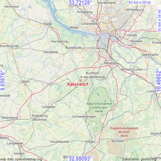
Kakenstorf GPS coordinates[2]
53° 18' 11.412" North, 9° 45' 46.404" East
| Map corner | latitude | longitude |
|---|---|---|
| Upper-left | 53.72128°, | 9.05976° |
| Center: | 53.30317°, | 9.76289° |
| Lower-right: | 52.88093°, | 10.46602° |
| Map W x H: | 93.4×93.4 km | = 58×58mi |
| max Lat: | 55.01917° ⇑16.3% North |
| Kakenstorf: | 53.30317° |
| min Lat: | ⇓83.7% South 47.40724° |
| min Long | Kakenstorf | max Long |
| 5.92978° | 9.76289° | 14.98853° |
| W 46.6%⇐ | ⇒53.4% E |
Elevation
Elevation of Kakenstorf is 41 m = 135 ft, and this is 208.1 m = 683 ft below average elevation for this country.
| Max E: |
1256 m = 4121 ft | 82.3% |
| Avg. | 249.1 m = 817 ft | |
| Kakenstorf | 41 m = 135 ft | |
Min E: |
-5 m = -16 ft | 17.7% |
See also: Germany elevation on elevation.city.
Geographical zone
Kakenstorf is located in North temperate zone (between Tropic of Cancer and the Arctic Circle). Distance of this North polar circle is 1474.4 km =916.1 mi to North.| Distance of | km | miles | from Kakenstorf |
|---|---|---|---|
| North Pole | 4080.3 | 2535.4 | to North |
| Arctic Circle | 1474.4 | 916.1 | to North |
| Tropic Cancer | 3320.8 | 2063.4 | to South |
| Equator | 5926.8 | 3682.7 | to South |


Nearby cities:
15 places around Kakenstorf: (largest is in red/bold)
• Appel
9.8 km =6.1 mi,  353°
353°
• Buchholz in der Nordheide
7.5 km =4.7 mi,  69°
69°
• Dohren
4.2 km =2.6 mi,  265°
265°
• Drestedt
3.1 km =1.9 mi, 353°
• Handeloh
8.2 km =5.1 mi,  141°
141°
• Heidenau
6.6 km =4.1 mi,  283°
283°
• Hollenstedt
7.7 km =4.8 mi,  336°
336°
• Königsmoor
10.2 km =6.3 mi,  212°
212°
• Moisburg
12.2 km =7.6 mi, 339°
• Otter
7.1 km =4.4 mi,  190°
190°
• Regesbostel
11.6 km =7.2 mi,  319°
319°
• Tostedt
3.8 km =2.4 mi,  234°
234°
• Welle
7.5 km =4.7 mi,  159°
159°
• Wenzendorf
5.2 km =3.2 mi,  6°
6°
• Wistedt
6.7 km =4.2 mi, 232°
Sources, notices
• [Note1] Compared only with cities in Germany existing in our database
• [Src1] Map data: © OpenStreetMap contributors (CC-BY-SA)
• [Src2] Other city data from geonames.org with taken over terms of usage.
• [Src3] Geographical zone / Annual Mean Temperature by Robert A. Rohde @ Wikipedia
