Gillersdorf geodata
Gillersdorf (Thuringia) is a seat of a fourth-order administrative division; located in Germany in Europe/Berlin (GMT+2) time zone. With population of 321 people, there are 9980 cities with bigger population in this country. Compared to other cities in Germany, 50.2% of cities are located further ↑North; 67.2% of cities are located further ←West and 99.1% of cities have lower elevation than Gillersdorf. Note1


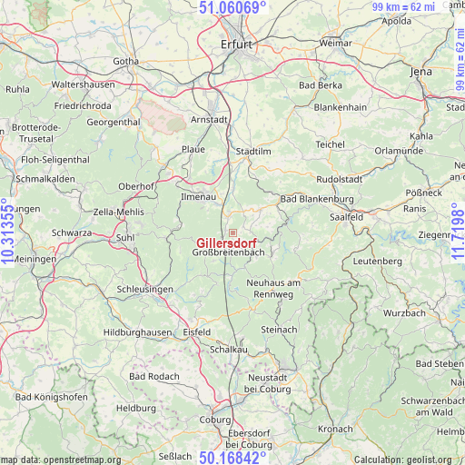
Gillersdorf GPS coordinates[2]
50° 37' 0.012" North, 11° 1' 0.012" East
| Map corner | latitude | longitude |
|---|---|---|
| Upper-left | 51.06069°, | 10.31355° |
| Center: | 50.61667°, | 11.01667° |
| Lower-right: | 50.16842°, | 11.7198° |
| Map W x H: | 99.2×99.2 km | = 61.6×61.6mi |
| max Lat: | 55.01917° ⇑50.2% North |
| Gillersdorf: | 50.61667° |
| min Lat: | ⇓49.8% South 47.40724° |
| min Long | Gillersdorf | max Long |
| 5.92978° | 11.01667° | 14.98853° |
| W 67.2%⇐ | ⇒32.8% E |
Elevation
Elevation of Gillersdorf is 800 m = 2625 ft, and this is 550.9 m = 1807 ft above average elevation for this country.
| Max E: |
1256 m = 4121 ft | 0.90000000000001% |
| Gillersdorf | 800 m 2625 ft | |
| Avg. | 249.1 m = 817 ft | |
Min E: |
-5 m = -16 ft | 99.1% |
See also: Germany elevation on elevation.city.
Geographical zone
Gillersdorf is located in North temperate zone (between Tropic of Cancer and the Arctic Circle). Distance of this North polar circle is 1773.1 km =1101.8 mi to North.| Distance of | km | miles | from Gillersdorf |
|---|---|---|---|
| North Pole | 4379 | 2721 | to North |
| Arctic Circle | 1773.1 | 1101.8 | to North |
| Tropic Cancer | 3022.1 | 1877.8 | to South |
| Equator | 5628 | 3497.1 | to South |


Nearby cities:
15 places around Gillersdorf: (largest is in red/bold)
• Altenfeld
6.6 km =4.1 mi,  212°
212°
• Böhlen
3.7 km =2.3 mi,  149°
149°
• Dröbischau
4.2 km =2.6 mi,  69°
69°
• Friedersdorf
1.9 km =1.2 mi,  134°
134°
• Gehren
3.6 km =2.2 mi,  346°
346°
• Großbreitenbach
3.7 km =2.3 mi,  187°
187°
• Herschdorf
2.7 km =1.7 mi,  58°
58°
• Königsee
7.6 km =4.7 mi,  48°
48°
• Langewiesen
7 km =4.3 mi,  332°
332°
• Mellenbach-Glasbach
5.9 km =3.7 mi,  90°
90°
• Meuselbach
7.3 km =4.5 mi, 133°
• Möhrenbach
1.7 km =1.1 mi,  296°
296°
• Neustadt am Rennsteig
7 km =4.3 mi,  237°
237°
• Pennewitz
5.4 km =3.4 mi,  28°
28°
• Wildenspring
4 km =2.5 mi,  117°
117°
Sources, notices
• [Note1] Compared only with cities in Germany existing in our database
• [Src1] Map data: © OpenStreetMap contributors (CC-BY-SA)
• [Src2] Other city data from geonames.org with taken over terms of usage.
• [Src3] Geographical zone / Annual Mean Temperature by Robert A. Rohde @ Wikipedia
