Mengkofen geodata
Mengkofen (Bavaria) is a seat of a fourth-order administrative division; located in Germany in Europe/Berlin (GMT+2) time zone. With population of 5,695 people, there are 2567 cities with bigger population in this country. Compared to other cities in Germany, 86.2% of cities are located further ↑North; 87.4% of cities are located further ←West and 75.2% of cities have lower elevation than Mengkofen. Note1
Administrative division(s):
- Level 1: Bavaria
- Level 2: Lower Bavaria
- Level 3: Landkreis Dingolfing-Landau
- Level 4: Mengkofen


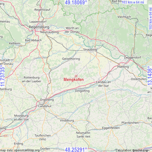
Mengkofen GPS coordinates[2]
48° 43' 8.184" North, 12° 26' 25.692" East
| Map corner | latitude | longitude |
|---|---|---|
| Upper-left | 49.18069°, | 11.73735° |
| Center: | 48.71894°, | 12.44047° |
| Lower-right: | 48.25291°, | 13.1436° |
| Map W x H: | 103.2×103.2 km | = 64.1×64.1mi |
| max Lat: | 55.01917° ⇑86.2% North |
| Mengkofen: | 48.71894° |
| min Lat: | ⇓13.8% South 47.40724° |
| min Long | Mengkofen | max Long |
| 5.92978° | 12.44047° | 14.98853° |
| W 87.4%⇐ | ⇒12.6% E |
Elevation
Elevation of Mengkofen is 399 m = 1309 ft, and this is 149.9 m = 492 ft above average elevation for this country.
| Max E: |
1256 m = 4121 ft | 24.8% |
| Mengkofen | 399 m 1309 ft | |
| Avg. | 249.1 m = 817 ft | |
Min E: |
-5 m = -16 ft | 75.2% |
See also: Germany elevation on elevation.city.
Geographical zone
Mengkofen is located in North temperate zone (between Tropic of Cancer and the Arctic Circle). Distance of this North polar circle is 1984.1 km =1232.9 mi to North.| Distance of | km | miles | from Mengkofen |
|---|---|---|---|
| North Pole | 4590 | 2852.1 | to North |
| Arctic Circle | 1984.1 | 1232.9 | to North |
| Tropic Cancer | 2811.1 | 1746.7 | to South |
| Equator | 5417 | 3366 | to South |


Nearby cities:
15 places around Mengkofen: (largest is in red/bold)
• Bayerbach
10.6 km =6.6 mi,  261°
261°
• Dingolfing
9.3 km =5.8 mi,  155°
155°
• Feldkirchen
14.7 km =9.1 mi,  25°
25°
• Geiselhöring
12.2 km =7.6 mi,  344°
344°
• Gottfrieding
11.4 km =7.1 mi,  142°
142°
• Laberweinting
12.8 km =8 mi,  314°
314°
• Leiblfing
8.5 km =5.3 mi,  42°
42°
• Loiching
11.4 km =7.1 mi,  182°
182°
• Mamming
14.4 km =8.9 mi,  121°
121°
• Moosthenning
6.3 km =3.9 mi, 138°
• Niederviehbach
12.1 km =7.5 mi,  200°
200°
• Postau
11 km =6.8 mi,  225°
225°
• Salching
13.9 km =8.6 mi, 43°
• Weng
8.5 km =5.3 mi,  217°
217°
• Wörth an der Isar
13 km =8.1 mi,  214°
214°
Sources, notices
• [Note1] Compared only with cities in Germany existing in our database
• [Src1] Map data: © OpenStreetMap contributors (CC-BY-SA)
• [Src2] Other city data from geonames.org with taken over terms of usage.
• [Src3] Geographical zone / Annual Mean Temperature by Robert A. Rohde @ Wikipedia
