Dingolfing geodata
Dingolfing (Bavaria) is a seat of a third-order administrative division; located in Germany in Europe/Berlin (GMT+2) time zone. With population of 18,805 people, there are 832 cities with bigger population in this country. Compared to other cities in Germany, 87.3% of cities are located further ↑North; 87.9% of cities are located further ←West and 69.9% of cities have lower elevation than Dingolfing. Note1
Administrative division(s):
- Level 1: Bavaria
- Level 2: Lower Bavaria
- Level 3: Landkreis Dingolfing-Landau
- Level 4: Dingolfing


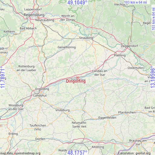
Dingolfing GPS coordinates[2]
48° 38' 32.784" North, 12° 29' 34.188" East
| Map corner | latitude | longitude |
|---|---|---|
| Upper-left | 49.1049°, | 11.78971° |
| Center: | 48.64244°, | 12.49283° |
| Lower-right: | 48.1757°, | 13.19596° |
| Map W x H: | 103.3×103.3 km | = 64.2×64.2mi |
| max Lat: | 55.01917° ⇑87.3% North |
| Dingolfing: | 48.64244° |
| min Lat: | ⇓12.7% South 47.40724° |
| min Long | Dingolfing | max Long |
| 5.92978° | 12.49283° | 14.98853° |
| W 87.9%⇐ | ⇒12.1% E |
Elevation
Elevation of Dingolfing is 357 m = 1171 ft, and this is 107.9 m = 354 ft above average elevation for this country.
| Max E: |
1256 m = 4121 ft | 30.1% |
| Dingolfing | 357 m 1171 ft | |
| Avg. | 249.1 m = 817 ft | |
Min E: |
-5 m = -16 ft | 69.9% |
See also: Germany elevation on elevation.city.
Geographical zone
Dingolfing is located in North temperate zone (between Tropic of Cancer and the Arctic Circle). Distance of this North polar circle is 1992.6 km =1238.1 mi to North.| Distance of | km | miles | from Dingolfing |
|---|---|---|---|
| North Pole | 4598.5 | 2857.4 | to North |
| Arctic Circle | 1992.6 | 1238.1 | to North |
| Tropic Cancer | 2802.6 | 1741.5 | to South |
| Equator | 5408.5 | 3360.7 | to South |


Nearby cities:
15 places around Dingolfing: (largest is in red/bold)
• Aham
13.1 km =8.1 mi,  190°
190°
• Frontenhausen
11.1 km =6.9 mi,  165°
165°
• Gottfrieding
3.2 km =2 mi,  100°
100°
• Loiching
5.2 km =3.2 mi,  236°
236°
• Mamming
8.5 km =5.3 mi,  83°
83°
• Marklkofen
11.6 km =7.2 mi,  152°
152°
• Mengkofen
9.3 km =5.8 mi,  335°
335°
• Moosthenning
3.8 km =2.4 mi,  5°
5°
• Niederaichbach
13.8 km =8.6 mi,  249°
249°
• Niederviehbach
8.5 km =5.3 mi, 250°
• Pilsting
13.3 km =8.3 mi,  60°
60°
• Postau
11.7 km =7.3 mi,  274°
274°
• Reisbach
12.8 km =8 mi,  128°
128°
• Weng
9.3 km =5.8 mi,  281°
281°
• Wörth an der Isar
11.5 km =7.1 mi,  259°
259°
Sources, notices
• [Note1] Compared only with cities in Germany existing in our database
• [Src1] Map data: © OpenStreetMap contributors (CC-BY-SA)
• [Src2] Other city data from geonames.org with taken over terms of usage.
• [Src3] Geographical zone / Annual Mean Temperature by Robert A. Rohde @ Wikipedia
