Altötting geodata
Altötting (Bavaria) is a seat of a third-order administrative division; located in Germany in Europe/Berlin (GMT+2) time zone. With population of 12,902 people, there are 1251 cities with bigger population in this country. Compared to other cities in Germany, 92.3% of cities are located further ↑North; 89.6% of cities are located further ←West and 76.1% of cities have lower elevation than Altötting. Note1
Administrative division(s):
- Level 1: Bavaria
- Level 2: Upper Bavaria
- Level 3: Landkreis Altötting
- Level 4: Altötting


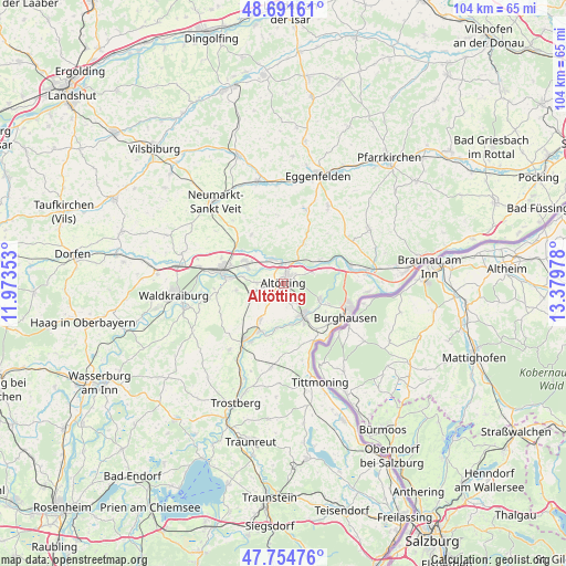
Altötting GPS coordinates[2]
48° 13' 31.188" North, 12° 40' 35.94" East
| Map corner | latitude | longitude |
|---|---|---|
| Upper-left | 48.69161°, | 11.97353° |
| Center: | 48.22533°, | 12.67665° |
| Lower-right: | 47.75476°, | 13.37978° |
| Map W x H: | 104.2×104.2 km | = 64.7×64.7mi |
| max Lat: | 55.01917° ⇑92.3% North |
| Altötting: | 48.22533° |
| min Lat: | ⇓7.7% South 47.40724° |
| min Long | Altötting | max Long |
| 5.92978° | 12.67665° | 14.98853° |
| W 89.6%⇐ | ⇒10.4% E |
Elevation
Elevation of Altötting is 406 m = 1332 ft, and this is 156.9 m = 515 ft above average elevation for this country.
| Max E: |
1256 m = 4121 ft | 23.9% |
| Altötting | 406 m 1332 ft | |
| Avg. | 249.1 m = 817 ft | |
Min E: |
-5 m = -16 ft | 76.1% |
See also: Germany elevation on elevation.city.
Geographical zone
Altötting is located in North temperate zone (between Tropic of Cancer and the Arctic Circle). Distance of this North polar circle is 2039 km =1267 mi to North.| Distance of | km | miles | from Altötting |
|---|---|---|---|
| North Pole | 4644.9 | 2886.2 | to North |
| Arctic Circle | 2039 | 1267 | to North |
| Tropic Cancer | 2756.2 | 1712.6 | to South |
| Equator | 5362.2 | 3331.9 | to South |


Nearby cities:
15 places around Altötting: (largest is in red/bold)
• Aresing
7.8 km =4.8 mi,  317°
317°
• Burgkirchen an der Alz
7.6 km =4.7 mi,  147°
147°
• Erharting
9.5 km =5.9 mi,  313°
313°
• Halsbach
10.2 km =6.3 mi,  177°
177°
• Kastl
3.3 km =2.1 mi, 148°
• Mehring
9.2 km =5.7 mi,  120°
120°
• Neuötting
2 km =1.2 mi,  29°
29°
• Perach
8.1 km =5 mi,  55°
55°
• Polling
8.2 km =5.1 mi,  263°
263°
• Reischach
8.1 km =5 mi, 26°
• Teising
4.8 km =3 mi,  272°
272°
• Töging am Inn
7.8 km =4.8 mi,  299°
299°
• Tüßling
5.9 km =3.7 mi, 255°
• Unterneukirchen
7.9 km =4.9 mi,  214°
214°
• Winhöring
5 km =3.1 mi,  336°
336°
Sources, notices
• [Note1] Compared only with cities in Germany existing in our database
• [Src1] Map data: © OpenStreetMap contributors (CC-BY-SA)
• [Src2] Other city data from geonames.org with taken over terms of usage.
• [Src3] Geographical zone / Annual Mean Temperature by Robert A. Rohde @ Wikipedia
