Neuötting geodata
Neuötting (Bavaria) is a populated place; located in Germany in Europe/Berlin (GMT+2) time zone. With population of 8,741 people, there are 1835 cities with bigger population in this country. Compared to other cities in Germany, 92.1% of cities are located further ↑North; 89.7% of cities are located further ←West and 73.9% of cities have lower elevation than Neuötting. Note1
Administrative division(s):
- Level 1: Bavaria
- Level 2: Upper Bavaria
- Level 3: Landkreis Altötting
- Level 4: Neuötting


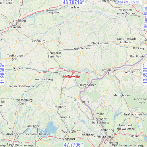
Neuötting GPS coordinates[2]
48° 14' 27.672" North, 12° 41' 23.928" East
| Map corner | latitude | longitude |
|---|---|---|
| Upper-left | 48.70716°, | 11.98686° |
| Center: | 48.24102°, | 12.68998° |
| Lower-right: | 47.7706°, | 13.39311° |
| Map W x H: | 104.1×104.1 km | = 64.7×64.7mi |
| max Lat: | 55.01917° ⇑92.1% North |
| Neuötting: | 48.24102° |
| min Lat: | ⇓7.9% South 47.40724° |
| min Long | Neuötting | max Long |
| 5.92978° | 12.68998° | 14.98853° |
| W 89.7%⇐ | ⇒10.3% E |
Elevation
Elevation of Neuötting is 389 m = 1276 ft, and this is 139.9 m = 459 ft above average elevation for this country.
| Max E: |
1256 m = 4121 ft | 26.1% |
| Neuötting | 389 m 1276 ft | |
| Avg. | 249.1 m = 817 ft | |
Min E: |
-5 m = -16 ft | 73.9% |
See also: Germany elevation on elevation.city.
Geographical zone
Neuötting is located in North temperate zone (between Tropic of Cancer and the Arctic Circle). Distance of this North polar circle is 2037.3 km =1265.9 mi to North.| Distance of | km | miles | from Neuötting |
|---|---|---|---|
| North Pole | 4643.2 | 2885.1 | to North |
| Arctic Circle | 2037.3 | 1265.9 | to North |
| Tropic Cancer | 2758 | 1713.7 | to South |
| Equator | 5363.9 | 3333 | to South |


Nearby cities:
15 places around Neuötting: (largest is in red/bold)
• Altötting
2 km =1.2 mi,  209°
209°
• Aresing
7.4 km =4.6 mi,  302°
302°
• Burgkirchen an der Alz
8.8 km =5.5 mi,  158°
158°
• Erharting
9.2 km =5.7 mi, 300°
• Erlbach
9.5 km =5.9 mi,  46°
46°
• Kastl
4.6 km =2.9 mi,  170°
170°
• Mehring
9.4 km =5.8 mi,  132°
132°
• Perach
6.4 km =4 mi,  63°
63°
• Polling
9.5 km =5.9 mi,  253°
253°
• Reischach
6.1 km =3.8 mi,  25°
25°
• Teising
6 km =3.7 mi,  255°
255°
• Töging am Inn
8.1 km =5 mi,  285°
285°
• Tüßling
7.4 km =4.6 mi,  244°
244°
• Unterneukirchen
9.9 km =6.2 mi, 213°
• Winhöring
4.1 km =2.5 mi,  313°
313°
Sources, notices
• [Note1] Compared only with cities in Germany existing in our database
• [Src1] Map data: © OpenStreetMap contributors (CC-BY-SA)
• [Src2] Other city data from geonames.org with taken over terms of usage.
• [Src3] Geographical zone / Annual Mean Temperature by Robert A. Rohde @ Wikipedia
