Harmstorf geodata
Harmstorf (Lower Saxony) is a seat of a fourth-order administrative division; located in Germany in Europe/Berlin (GMT+2) time zone. With population of 913 people, there are 7478 cities with bigger population in this country. Compared to other cities in Germany, 84.1% of cities are located further ↓South; 50.3% of cities are located further →East and 86.3% of cities have higher elevation than Harmstorf. Note1


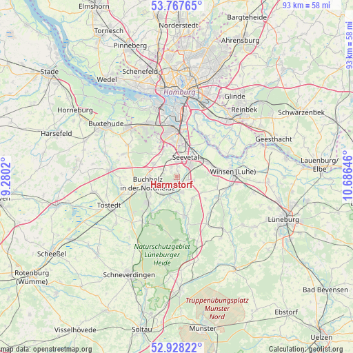
Harmstorf GPS coordinates[2]
53° 21' 0" North, 9° 58' 59.988" East
| Map corner | latitude | longitude |
|---|---|---|
| Upper-left | 53.76765°, | 9.2802° |
| Center: | 53.35°, | 9.98333° |
| Lower-right: | 52.92822°, | 10.68646° |
| Map W x H: | 93.3×93.3 km | = 58×58mi |
| max Lat: | 55.01917° ⇑15.9% North |
| Harmstorf: | 53.35° |
| min Lat: | ⇓84.1% South 47.40724° |
| min Long | Harmstorf | max Long |
| 5.92978° | 9.98333° | 14.98853° |
| W 49.7%⇐ | ⇒50.3% E |
Elevation
Elevation of Harmstorf is 32 m = 105 ft, and this is 217.1 m = 712 ft below average elevation for this country.
| Max E: |
1256 m = 4121 ft | 86.3% |
| Avg. | 249.1 m = 817 ft | |
| Harmstorf | 32 m = 105 ft | |
Min E: |
-5 m = -16 ft | 13.7% |
See also: Germany elevation on elevation.city.
Geographical zone
Harmstorf is located in North temperate zone (between Tropic of Cancer and the Arctic Circle). Distance of this North polar circle is 1469.2 km =912.9 mi to North.| Distance of | km | miles | from Harmstorf |
|---|---|---|---|
| North Pole | 4075.1 | 2532.1 | to North |
| Arctic Circle | 1469.2 | 912.9 | to North |
| Tropic Cancer | 3326 | 2066.7 | to South |
| Equator | 5932 | 3686 | to South |


Nearby cities:
15 places around Harmstorf: (largest is in red/bold)
• Asendorf
6.4 km =4 mi,  182°
182°
• Bendestorf
2.1 km =1.3 mi,  222°
222°
• Brackel
7.1 km =4.4 mi,  142°
142°
• Buchholz in der Nordheide
8.1 km =5 mi,  251°
251°
• Garlstorf
14.8 km =9.2 mi,  147°
147°
• Garstedt
13.9 km =8.6 mi,  121°
121°
• Hanstedt
9.5 km =5.9 mi,  166°
166°
• Harburg
12.3 km =7.6 mi,  0°
0°
• Jesteburg
4.9 km =3 mi,  204°
204°
• Marxen
4.4 km =2.7 mi,  161°
161°
• Seevetal
5.7 km =3.5 mi,  348°
348°
• Stelle
9.3 km =5.8 mi,  65°
65°
• Toppenstedt
12.9 km =8 mi, 137°
• Wenzendorf
14 km =8.7 mi,  269°
269°
• Wulfsen
12.4 km =7.7 mi, 116°
Sources, notices
• [Note1] Compared only with cities in Germany existing in our database
• [Src1] Map data: © OpenStreetMap contributors (CC-BY-SA)
• [Src2] Other city data from geonames.org with taken over terms of usage.
• [Src3] Geographical zone / Annual Mean Temperature by Robert A. Rohde @ Wikipedia
