Buchholz in der Nordheide geodata
Buchholz in der Nordheide (Lower Saxony) is a populated place; located in Germany in Europe/Berlin (GMT+2) time zone. With population of 37,404 people, there are 357 cities with bigger population in this country. Compared to other cities in Germany, 83.9% of cities are located further ↓South; 51.9% of cities are located further →East and 72.4% of cities have higher elevation than Buchholz in der Nordheide. Note1
Administrative division(s):
- Level 1: Lower Saxony
- Level 3: Landkreis Harburg
- Level 4: Buchholz in der Nordheide
Current local time in Buchholz in der Nordheide:
02:45 PM, TuesdayDifference from your time zone: hours


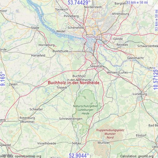
Buchholz in der Nordheide GPS coordinates[2]
53° 19' 35.076" North, 9° 52' 5.232" East
| Map corner | latitude | longitude |
|---|---|---|
| Upper-left | 53.74429°, | 9.165° |
| Center: | 53.32641°, | 9.86812° |
| Lower-right: | 52.9044°, | 10.57125° |
| Map W x H: | 93.4×93.4 km | = 58×58mi |
| max Lat: | 55.01917° ⇑16.1% North |
| Buchholz in der Nordheide: | 53.32641° |
| min Lat: | ⇓83.9% South 47.40724° |
| min Long | Buchholz in der | max Long |
| 5.92978° | 9.86812° | 14.98853° |
| W 48.1%⇐ | ⇒51.9% E |
Elevation
Elevation of Buchholz in der Nordheide is 75 m = 246 ft, and this is 174.1 m = 571 ft below average elevation for this country.
| Max E: |
1256 m = 4121 ft | 72.4% |
| Avg. | 249.1 m = 817 ft | |
| Buchholz in der Nordheide | 75 m = 246 ft | |
Min E: |
-5 m = -16 ft | 27.6% |
See also: Germany elevation on elevation.city.
Geographical zone
Buchholz in der Nordheide is located in North temperate zone (between Tropic of Cancer and the Arctic Circle). Distance of this North polar circle is 1471.8 km =914.5 mi to North.| Distance of | km | miles | from Buchholz in der Nordheide |
|---|---|---|---|
| North Pole | 4077.7 | 2533.8 | to North |
| Arctic Circle | 1471.8 | 914.5 | to North |
| Tropic Cancer | 3323.4 | 2065.1 | to South |
| Equator | 5929.3 | 3684.3 | to South |


Nearby cities:
15 places around Buchholz in der Nordheide: (largest is in red/bold)
• Appel
10.8 km =6.7 mi,  311°
311°
• Asendorf
8.3 km =5.2 mi,  116°
116°
• Bendestorf
6.3 km =3.9 mi,  80°
80°
• Dohren
11.5 km =7.1 mi,  255°
255°
• Drestedt
7.4 km =4.6 mi,  273°
273°
• Handeloh
9.2 km =5.7 mi,  192°
192°
• Harmstorf
8.1 km =5 mi,  71°
71°
• Hollenstedt
11 km =6.8 mi,  294°
294°
• Jesteburg
5.9 km =3.7 mi,  108°
108°
• Kakenstorf
7.5 km =4.7 mi,  249°
249°
• Marxen
9.2 km =5.7 mi,  99°
99°
• Seevetal
10.5 km =6.5 mi,  38°
38°
• Tostedt
11.1 km =6.9 mi,  244°
244°
• Welle
10.6 km =6.6 mi,  204°
204°
• Wenzendorf
6.9 km =4.3 mi, 291°
In other languages:
- In Russian: Бухгольц-ин-дер-Нордхайде, Буххольц-ин-дер-Нордхайде
- In Chinese: 诺尔登堤岸布赫霍尔茨
Sources, notices
• [Note1] Compared only with cities in Germany existing in our database
• [Src1] Map data: © OpenStreetMap contributors (CC-BY-SA)
• [Src2] Other city data from geonames.org with taken over terms of usage.
• [Src3] Geographical zone / Annual Mean Temperature by Robert A. Rohde @ Wikipedia
