Marktoberdorf geodata
Marktoberdorf (Bavaria) is a seat of a third-order administrative division; located in Germany in Europe/Berlin (GMT+2) time zone. With population of 18,505 people, there are 848 cities with bigger population in this country. Compared to other cities in Germany, 97.9% of cities are located further ↑North; 61.1% of cities are located further ←West and 98.4% of cities have lower elevation than Marktoberdorf. Note1
Administrative division(s):
- Level 1: Bavaria
- Level 2: Swabia
- Level 3: Landkreis Ostallgäu
- Level 4: Marktoberdorf


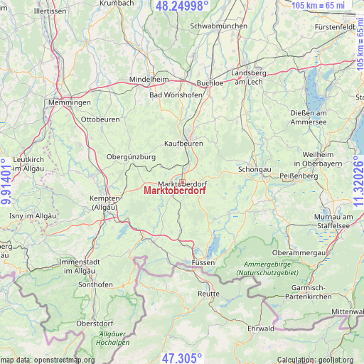
Marktoberdorf GPS coordinates[2]
47° 46' 46.704" North, 10° 37' 1.668" East
| Map corner | latitude | longitude |
|---|---|---|
| Upper-left | 48.24998°, | 9.91401° |
| Center: | 47.77964°, | 10.61713° |
| Lower-right: | 47.305°, | 11.32026° |
| Map W x H: | 105.1×105.1 km | = 65.3×65.3mi |
| max Lat: | 55.01917° ⇑97.9% North |
| Marktoberdorf: | 47.77964° |
| min Lat: | ⇓2.1% South 47.40724° |
| min Long | Marktoberdorf | max Long |
| 5.92978° | 10.61713° | 14.98853° |
| W 61.1%⇐ | ⇒38.9% E |
Elevation
Elevation of Marktoberdorf is 728 m = 2388 ft, and this is 478.9 m = 1571 ft above average elevation for this country.
| Max E: |
1256 m = 4121 ft | 1.6% |
| Marktoberdorf | 728 m 2388 ft | |
| Avg. | 249.1 m = 817 ft | |
Min E: |
-5 m = -16 ft | 98.4% |
See also: Germany elevation on elevation.city.
Geographical zone
Marktoberdorf is located in North temperate zone (between Tropic of Cancer and the Arctic Circle). Distance of this North polar circle is 2088.6 km =1297.8 mi to North.| Distance of | km | miles | from Marktoberdorf |
|---|---|---|---|
| North Pole | 4694.5 | 2917 | to North |
| Arctic Circle | 2088.6 | 1297.8 | to North |
| Tropic Cancer | 2706.7 | 1681.9 | to South |
| Equator | 5312.6 | 3301.1 | to South |


Nearby cities:
15 places around Marktoberdorf: (largest is in red/bold)
• Aitrang
7.5 km =4.7 mi,  303°
303°
• Bernbeuren
12.9 km =8 mi,  111°
111°
• Bidingen
9.9 km =6.2 mi,  55°
55°
• Biessenhofen
5.9 km =3.7 mi,  16°
16°
• Friesenried
12.2 km =7.6 mi,  329°
329°
• Görisried
11.4 km =7.1 mi,  224°
224°
• Ingenried
13.1 km =8.1 mi,  71°
71°
• Kaufbeuren
11.4 km =7.1 mi,  1°
1°
• Kraftisried
10.9 km =6.8 mi,  269°
269°
• Lengenwang
8.9 km =5.5 mi,  188°
188°
• Mauerstetten
13.3 km =8.3 mi, 17°
• Ruderatshofen
4.8 km =3 mi, 328°
• Stötten am Auerberg
7 km =4.3 mi,  130°
130°
• Unterthingau
8.5 km =5.3 mi,  263°
263°
• Wald
7.7 km =4.8 mi,  214°
214°
Sources, notices
• [Note1] Compared only with cities in Germany existing in our database
• [Src1] Map data: © OpenStreetMap contributors (CC-BY-SA)
• [Src2] Other city data from geonames.org with taken over terms of usage.
• [Src3] Geographical zone / Annual Mean Temperature by Robert A. Rohde @ Wikipedia
