Marienberg geodata
Marienberg (Saxony) is a populated place; located in Germany in Europe/Berlin (GMT+2) time zone. With population of 14,383 people, there are 1100 cities with bigger population in this country. Compared to other cities in Germany, 50.9% of cities are located further ↓South; 93.4% of cities are located further ←West and 95.6% of cities have lower elevation than Marienberg. Note1


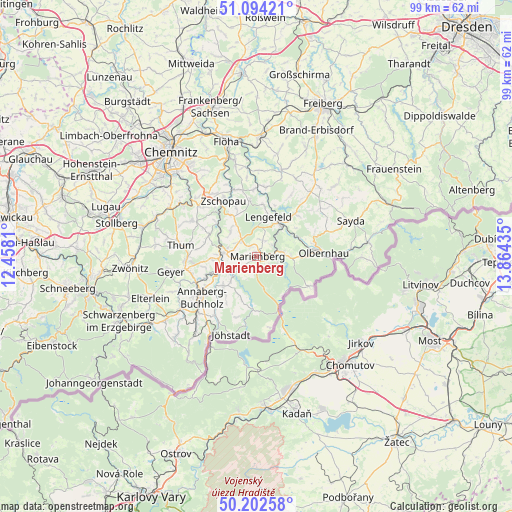
Marienberg GPS coordinates[2]
50° 39' 1.836" North, 13° 9' 40.392" East
| Map corner | latitude | longitude |
|---|---|---|
| Upper-left | 51.09421°, | 12.4581° |
| Center: | 50.65051°, | 13.16122° |
| Lower-right: | 50.20258°, | 13.86435° |
| Map W x H: | 99.1×99.1 km | = 61.6×61.6mi |
| max Lat: | 55.01917° ⇑49.1% North |
| Marienberg: | 50.65051° |
| min Lat: | ⇓50.9% South 47.40724° |
| min Long | Marienberg | max Long |
| 5.92978° | 13.16122° | 14.98853° |
| W 93.4%⇐ | ⇒6.6% E |
Elevation
Elevation of Marienberg is 614 m = 2014 ft, and this is 364.9 m = 1197 ft above average elevation for this country.
| Max E: |
1256 m = 4121 ft | 4.4% |
| Marienberg | 614 m 2014 ft | |
| Avg. | 249.1 m = 817 ft | |
Min E: |
-5 m = -16 ft | 95.6% |
See also: Germany elevation on elevation.city.
Geographical zone
Marienberg is located in North temperate zone (between Tropic of Cancer and the Arctic Circle). Distance of this North polar circle is 1769.4 km =1099.5 mi to North.| Distance of | km | miles | from Marienberg |
|---|---|---|---|
| North Pole | 4375.3 | 2718.7 | to North |
| Arctic Circle | 1769.4 | 1099.5 | to North |
| Tropic Cancer | 3025.9 | 1880.2 | to South |
| Equator | 5631.8 | 3499.4 | to South |


Nearby cities:
15 places around Marienberg: (largest is in red/bold)
• Börnichen
11.2 km =7 mi,  352°
352°
• Drebach
10.6 km =6.6 mi,  285°
285°
• Großolbersdorf
7.8 km =4.8 mi,  315°
315°
• Großrückerswalde
3.7 km =2.3 mi,  238°
238°
• Lengefeld
7.9 km =4.9 mi,  16°
16°
• Mildenau
9.4 km =5.8 mi,  221°
221°
• Pobershau
4.1 km =2.5 mi,  105°
105°
• Pockau
7.5 km =4.7 mi,  42°
42°
• Scharfenstein
9.5 km =5.9 mi,  308°
308°
• Thermalbad Wiesenbad
8.7 km =5.4 mi, 244°
• Venusberg
11.4 km =7.1 mi,  298°
298°
• Wiesa
11.3 km =7 mi,  247°
247°
• Wolkenstein
6.4 km =4 mi,  275°
275°
• Zschopau
12.4 km =7.7 mi,  331°
331°
• Zöblitz
4.9 km =3 mi,  78°
78°
Sources, notices
• [Note1] Compared only with cities in Germany existing in our database
• [Src1] Map data: © OpenStreetMap contributors (CC-BY-SA)
• [Src2] Other city data from geonames.org with taken over terms of usage.
• [Src3] Geographical zone / Annual Mean Temperature by Robert A. Rohde @ Wikipedia
