Wiesa geodata
Wiesa (Saxony) is a populated place; located in Germany in Europe/Berlin (GMT+2) time zone. With population of 3,811 people, there are 3398 cities with bigger population in this country. Compared to other cities in Germany, 50.2% of cities are located further ↑North; 92.4% of cities are located further ←West and 83.6% of cities have lower elevation than Wiesa. Note1


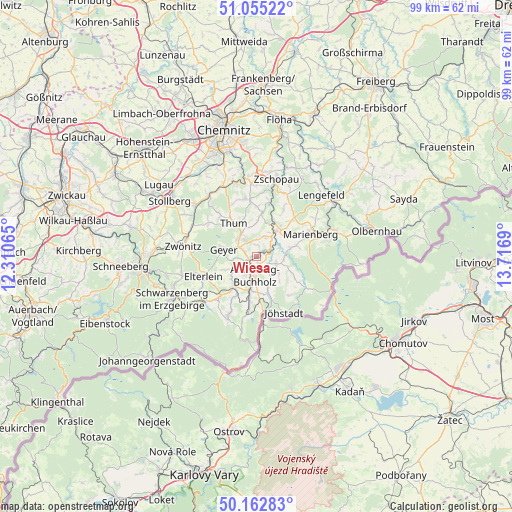
Wiesa GPS coordinates[2]
50° 36' 40.104" North, 13° 0' 49.572" East
| Map corner | latitude | longitude |
|---|---|---|
| Upper-left | 51.05522°, | 12.31065° |
| Center: | 50.61114°, | 13.01377° |
| Lower-right: | 50.16283°, | 13.7169° |
| Map W x H: | 99.2×99.2 km | = 61.6×61.6mi |
| max Lat: | 55.01917° ⇑50.2% North |
| Wiesa: | 50.61114° |
| min Lat: | ⇓49.8% South 47.40724° |
| min Long | Wiesa | max Long |
| 5.92978° | 13.01377° | 14.98853° |
| W 92.4%⇐ | ⇒7.6% E |
Elevation
Elevation of Wiesa is 458 m = 1503 ft, and this is 208.9 m = 685 ft above average elevation for this country.
| Max E: |
1256 m = 4121 ft | 16.4% |
| Wiesa | 458 m 1503 ft | |
| Avg. | 249.1 m = 817 ft | |
Min E: |
-5 m = -16 ft | 83.6% |
See also: Germany elevation on elevation.city.
Geographical zone
Wiesa is located in North temperate zone (between Tropic of Cancer and the Arctic Circle). Distance of this North polar circle is 1773.7 km =1102.1 mi to North.| Distance of | km | miles | from Wiesa |
|---|---|---|---|
| North Pole | 4379.6 | 2721.4 | to North |
| Arctic Circle | 1773.7 | 1102.1 | to North |
| Tropic Cancer | 3021.5 | 1877.5 | to South |
| Equator | 5627.4 | 3496.7 | to South |


Nearby cities:
15 places around Wiesa: (largest is in red/bold)
• Annaberg-Buchholz
3.6 km =2.2 mi,  188°
188°
• Auerbach
10.5 km =6.5 mi,  319°
319°
• Drebach
7.2 km =4.5 mi,  1°
1°
• Ehrenfriedersdorf
5.2 km =3.2 mi, 324°
• Geyer
6.8 km =4.2 mi,  284°
284°
• Großrückerswalde
7.7 km =4.8 mi,  71°
71°
• Königswalde
7.3 km =4.5 mi,  159°
159°
• Mildenau
5 km =3.1 mi,  122°
122°
• Scheibenberg
10.7 km =6.6 mi,  222°
222°
• Schlettau
7.2 km =4.5 mi, 216°
• Tannenberg
5.4 km =3.4 mi,  265°
265°
• Thermalbad Wiesenbad
2.6 km =1.6 mi,  76°
76°
• Thum
8 km =5 mi,  326°
326°
• Venusberg
9.8 km =6.1 mi, 1°
• Wolkenstein
6.4 km =4 mi,  39°
39°
Sources, notices
• [Note1] Compared only with cities in Germany existing in our database
• [Src1] Map data: © OpenStreetMap contributors (CC-BY-SA)
• [Src2] Other city data from geonames.org with taken over terms of usage.
• [Src3] Geographical zone / Annual Mean Temperature by Robert A. Rohde @ Wikipedia
