Großrückerswalde geodata
Großrückerswalde (Saxony) is a seat of a fourth-order administrative division; located in Germany in Europe/Berlin (GMT+2) time zone. With population of 4,005 people, there are 3297 cities with bigger population in this country. Compared to other cities in Germany, 50.3% of cities are located further ↓South; 93.1% of cities are located further ←West and 95.7% of cities have lower elevation than Großrückerswalde. Note1


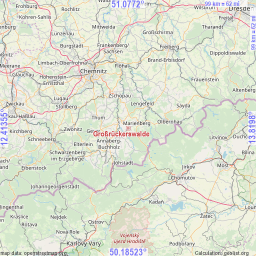
Großrückerswalde GPS coordinates[2]
50° 37' 59.988" North, 13° 7' 0.012" East
| Map corner | latitude | longitude |
|---|---|---|
| Upper-left | 51.0772°, | 12.41355° |
| Center: | 50.63333°, | 13.11667° |
| Lower-right: | 50.18523°, | 13.8198° |
| Map W x H: | 99.2×99.2 km | = 61.6×61.6mi |
| max Lat: | 55.01917° ⇑49.7% North |
| Großrückerswalde: | 50.63333° |
| min Lat: | ⇓50.3% South 47.40724° |
| min Long | Großrückerswa | max Long |
| 5.92978° | 13.11667° | 14.98853° |
| W 93.1%⇐ | ⇒6.9% E |
Elevation
Elevation of Großrückerswalde is 615 m = 2018 ft, and this is 365.9 m = 1200 ft above average elevation for this country.
| Max E: |
1256 m = 4121 ft | 4.3% |
| Großrückerswalde | 615 m 2018 ft | |
| Avg. | 249.1 m = 817 ft | |
Min E: |
-5 m = -16 ft | 95.7% |
See also: Germany elevation on elevation.city.
Geographical zone
Großrückerswalde is located in North temperate zone (between Tropic of Cancer and the Arctic Circle). Distance of this North polar circle is 1771.3 km =1100.6 mi to North.| Distance of | km | miles | from Großrückerswalde |
|---|---|---|---|
| North Pole | 4377.2 | 2719.9 | to North |
| Arctic Circle | 1771.3 | 1100.6 | to North |
| Tropic Cancer | 3024 | 1879 | to South |
| Equator | 5629.9 | 3498.3 | to South |


Nearby cities:
15 places around Großrückerswalde: (largest is in red/bold)
• Annaberg-Buchholz
9.8 km =6.1 mi,  232°
232°
• Drebach
8.5 km =5.3 mi,  303°
303°
• Ehrenfriedersdorf
10.5 km =6.5 mi,  279°
279°
• Großolbersdorf
7.8 km =4.8 mi,  342°
342°
• Königswalde
10.4 km =6.5 mi,  206°
206°
• Lengefeld
10.9 km =6.8 mi,  29°
29°
• Marienberg
3.7 km =2.3 mi,  58°
58°
• Mildenau
6 km =3.7 mi, 211°
• Pobershau
7.2 km =4.5 mi,  83°
83°
• Scharfenstein
8.9 km =5.5 mi,  331°
331°
• Thermalbad Wiesenbad
5.1 km =3.2 mi,  248°
248°
• Venusberg
10.1 km =6.3 mi,  316°
316°
• Wiesa
7.7 km =4.8 mi, 251°
• Wolkenstein
4 km =2.5 mi,  307°
307°
• Zöblitz
8.5 km =5.3 mi,  70°
70°
Sources, notices
• [Note1] Compared only with cities in Germany existing in our database
• [Src1] Map data: © OpenStreetMap contributors (CC-BY-SA)
• [Src2] Other city data from geonames.org with taken over terms of usage.
• [Src3] Geographical zone / Annual Mean Temperature by Robert A. Rohde @ Wikipedia
