Malching geodata
Malching (Bavaria) is a seat of a fourth-order administrative division; located in Germany in Europe/Berlin (GMT+2) time zone. With population of 1,285 people, there are 6349 cities with bigger population in this country. Compared to other cities in Germany, 91.1% of cities are located further ↑North; 93.6% of cities are located further ←West and 68.1% of cities have lower elevation than Malching. Note1
Administrative division(s):
- Level 1: Bavaria
- Level 2: Lower Bavaria
- Level 3: Landkreis Passau
- Level 4: Malching


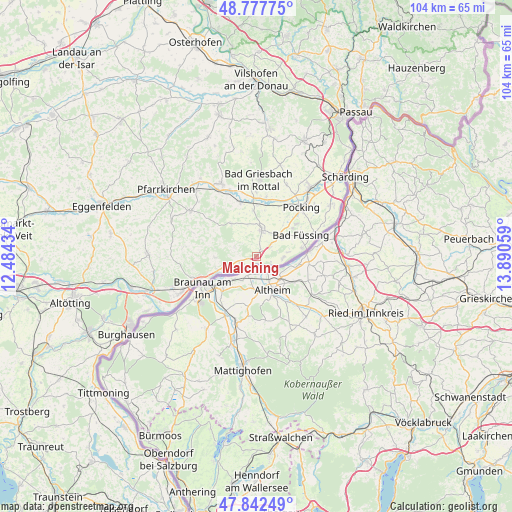
Malching GPS coordinates[2]
48° 18' 44.136" North, 13° 11' 14.856" East
| Map corner | latitude | longitude |
|---|---|---|
| Upper-left | 48.77775°, | 12.48434° |
| Center: | 48.31226°, | 13.18746° |
| Lower-right: | 47.84249°, | 13.89059° |
| Map W x H: | 104×104 km | = 64.6×64.6mi |
| max Lat: | 55.01917° ⇑91.1% North |
| Malching: | 48.31226° |
| min Lat: | ⇓8.9% South 47.40724° |
| min Long | Malching | max Long |
| 5.92978° | 13.18746° | 14.98853° |
| W 93.6%⇐ | ⇒6.4% E |
Elevation
Elevation of Malching is 343 m = 1125 ft, and this is 93.9 m = 308 ft above average elevation for this country.
| Max E: |
1256 m = 4121 ft | 31.9% |
| Malching | 343 m 1125 ft | |
| Avg. | 249.1 m = 817 ft | |
Min E: |
-5 m = -16 ft | 68.1% |
See also: Germany elevation on elevation.city.
Geographical zone
Malching is located in North temperate zone (between Tropic of Cancer and the Arctic Circle). Distance of this North polar circle is 2029.4 km =1261 mi to North.| Distance of | km | miles | from Malching |
|---|---|---|---|
| North Pole | 4635.2 | 2880.2 | to North |
| Arctic Circle | 2029.4 | 1261 | to North |
| Tropic Cancer | 2765.9 | 1718.7 | to South |
| Equator | 5371.8 | 3337.9 | to South |


Nearby cities:
15 places around Malching: (largest is in red/bold)
• Bad Birnbach
16.4 km =10.2 mi,  334°
334°
• Bad Füssing
10.2 km =6.3 mi,  64°
64°
• Bad Griesbach
15.5 km =9.6 mi,  1°
1°
• Bayerbach
11.3 km =7 mi,  343°
343°
• Chostlarn
8.2 km =5.1 mi,  323°
323°
• Ering
3.1 km =1.9 mi,  242°
242°
• Kirchdorf am Inn
16.7 km =10.4 mi, 244°
• Kirchham
7 km =4.3 mi, 57°
• Pocking
13.6 km =8.5 mi,  43°
43°
• Rotthalmünster
5.2 km =3.2 mi,  11°
11°
• Simbach am Inn
13.2 km =8.2 mi,  246°
246°
• Stubenberg
7.7 km =4.8 mi,  273°
273°
• Tettenweis
15.7 km =9.8 mi,  22°
22°
• Triftern
16.2 km =10.1 mi,  304°
304°
• Wittibreut
14.9 km =9.3 mi,  277°
277°
Sources, notices
• [Note1] Compared only with cities in Germany existing in our database
• [Src1] Map data: © OpenStreetMap contributors (CC-BY-SA)
• [Src2] Other city data from geonames.org with taken over terms of usage.
• [Src3] Geographical zone / Annual Mean Temperature by Robert A. Rohde @ Wikipedia
