Bad Birnbach geodata
Bad Birnbach (Bavaria) is a populated place; located in Germany in Europe/Berlin (GMT+2) time zone. With population of 5,533 people, there are 2615 cities with bigger population in this country. Compared to other cities in Germany, 89.7% of cities are located further ↑North; 92.9% of cities are located further ←West and 70.3% of cities have lower elevation than Bad Birnbach. Note1
Administrative division(s):
- Level 1: Bavaria
- Level 2: Lower Bavaria
- Level 3: Landkreis Rottal-Inn
- Level 4: Bad Birnbach, Markt


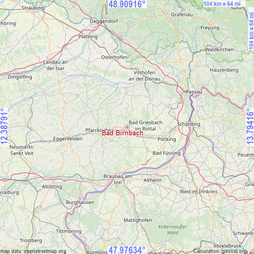
Bad Birnbach GPS coordinates[2]
48° 26' 41.604" North, 13° 5' 27.708" East
| Map corner | latitude | longitude |
|---|---|---|
| Upper-left | 48.90916°, | 12.38791° |
| Center: | 48.44489°, | 13.09103° |
| Lower-right: | 47.97634°, | 13.79416° |
| Map W x H: | 103.7×103.7 km | = 64.4×64.4mi |
| max Lat: | 55.01917° ⇑89.7% North |
| Bad Birnbach: | 48.44489° |
| min Lat: | ⇓10.3% South 47.40724° |
| min Long | Bad Birnbach | max Long |
| 5.92978° | 13.09103° | 14.98853° |
| W 92.9%⇐ | ⇒7.1% E |
Elevation
Elevation of Bad Birnbach is 360 m = 1181 ft, and this is 110.9 m = 364 ft above average elevation for this country.
| Max E: |
1256 m = 4121 ft | 29.7% |
| Bad Birnbach | 360 m 1181 ft | |
| Avg. | 249.1 m = 817 ft | |
Min E: |
-5 m = -16 ft | 70.3% |
See also: Germany elevation on elevation.city.
Geographical zone
Bad Birnbach is located in North temperate zone (between Tropic of Cancer and the Arctic Circle). Distance of this North polar circle is 2014.6 km =1251.8 mi to North.| Distance of | km | miles | from Bad Birnbach |
|---|---|---|---|
| North Pole | 4620.5 | 2871 | to North |
| Arctic Circle | 2014.6 | 1251.8 | to North |
| Tropic Cancer | 2780.6 | 1727.8 | to South |
| Equator | 5386.6 | 3347.1 | to South |


Nearby cities:
15 places around Bad Birnbach: (largest is in red/bold)
• Aidenbach
13.9 km =8.6 mi,  359°
359°
• Bad Griesbach
7.6 km =4.7 mi,  84°
84°
• Bayerbach
5.5 km =3.4 mi,  134°
134°
• Beutelsbach
11.8 km =7.3 mi,  9°
9°
• Chostlarn
8.5 km =5.3 mi,  165°
165°
• Dietersburg
13.3 km =8.3 mi,  293°
293°
• Egglham
9.7 km =6 mi,  343°
343°
• Haarbach
7.5 km =4.7 mi,  35°
35°
• Haibach
12.8 km =8 mi,  322°
322°
• Johanniskirchen
14.3 km =8.9 mi,  313°
313°
• Pfarrkirchen
11.4 km =7.1 mi,  262°
262°
• Rotthalmünster
12.6 km =7.8 mi,  139°
139°
• Stubenberg
14.3 km =8.9 mi,  182°
182°
• Tettenweis
13.2 km =8.2 mi,  91°
91°
• Triftern
8.4 km =5.2 mi,  228°
228°
Sources, notices
• [Note1] Compared only with cities in Germany existing in our database
• [Src1] Map data: © OpenStreetMap contributors (CC-BY-SA)
• [Src2] Other city data from geonames.org with taken over terms of usage.
• [Src3] Geographical zone / Annual Mean Temperature by Robert A. Rohde @ Wikipedia
