Triftern geodata
Triftern (Bavaria) is a populated place; located in Germany in Europe/Berlin (GMT+2) time zone. With population of 5,419 people, there are 2659 cities with bigger population in this country. Compared to other cities in Germany, 90.3% of cities are located further ↑North; 92.4% of cities are located further ←West and 74.3% of cities have lower elevation than Triftern. Note1
Administrative division(s):
- Level 1: Bavaria
- Level 2: Lower Bavaria
- Level 3: Landkreis Rottal-Inn
- Level 4: Triftern, Markt


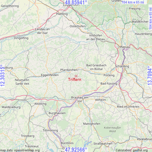
Triftern GPS coordinates[2]
48° 23' 40.848" North, 13° 0' 22.572" East
| Map corner | latitude | longitude |
|---|---|---|
| Upper-left | 48.85941°, | 12.30315° |
| Center: | 48.39468°, | 13.00627° |
| Lower-right: | 47.92566°, | 13.7094° |
| Map W x H: | 103.8×103.8 km | = 64.5×64.5mi |
| max Lat: | 55.01917° ⇑90.3% North |
| Triftern: | 48.39468° |
| min Lat: | ⇓9.7% South 47.40724° |
| min Long | Triftern | max Long |
| 5.92978° | 13.00627° | 14.98853° |
| W 92.4%⇐ | ⇒7.6% E |
Elevation
Elevation of Triftern is 392 m = 1286 ft, and this is 142.9 m = 469 ft above average elevation for this country.
| Max E: |
1256 m = 4121 ft | 25.7% |
| Triftern | 392 m 1286 ft | |
| Avg. | 249.1 m = 817 ft | |
Min E: |
-5 m = -16 ft | 74.3% |
See also: Germany elevation on elevation.city.
Geographical zone
Triftern is located in North temperate zone (between Tropic of Cancer and the Arctic Circle). Distance of this North polar circle is 2020.2 km =1255.3 mi to North.| Distance of | km | miles | from Triftern |
|---|---|---|---|
| North Pole | 4626.1 | 2874.5 | to North |
| Arctic Circle | 2020.2 | 1255.3 | to North |
| Tropic Cancer | 2775.1 | 1724.4 | to South |
| Equator | 5381 | 3343.6 | to South |


Nearby cities:
15 places around Triftern: (largest is in red/bold)
• Bad Birnbach
8.4 km =5.2 mi,  48°
48°
• Bad Griesbach
15.2 km =9.4 mi,  65°
65°
• Bayerbach
10.3 km =6.4 mi,  80°
80°
• Chostlarn
8.8 km =5.5 mi,  107°
107°
• Dietersburg
12.4 km =7.7 mi,  331°
331°
• Ering
15 km =9.3 mi,  134°
134°
• Hebertsfelden
13.6 km =8.5 mi,  275°
275°
• Pfarrkirchen
6.5 km =4 mi,  309°
309°
• Postmünster
8.2 km =5.1 mi,  287°
287°
• Reut
10.2 km =6.3 mi,  211°
211°
• Rotthalmünster
15 km =9.3 mi, 105°
• Simbach am Inn
14.4 km =8.9 mi,  175°
175°
• Stubenberg
10.4 km =6.5 mi,  146°
146°
• Tann
12.2 km =7.6 mi,  223°
223°
• Wittibreut
7.4 km =4.6 mi,  191°
191°
Sources, notices
• [Note1] Compared only with cities in Germany existing in our database
• [Src1] Map data: © OpenStreetMap contributors (CC-BY-SA)
• [Src2] Other city data from geonames.org with taken over terms of usage.
• [Src3] Geographical zone / Annual Mean Temperature by Robert A. Rohde @ Wikipedia
