Schnega geodata
Schnega (Lower Saxony) is a seat of a fourth-order administrative division; located in Germany in Europe/Berlin (GMT+2) time zone. With population of 1,488 people, there are 5909 cities with bigger population in this country. Compared to other cities in Germany, 81% of cities are located further ↓South; 65.4% of cities are located further ←West and 82.8% of cities have higher elevation than Schnega. Note1
Administrative division(s):
- Level 1: Lower Saxony
- Level 3: Landkreis Lüchow-Dannenberg
- Level 4: Schnega


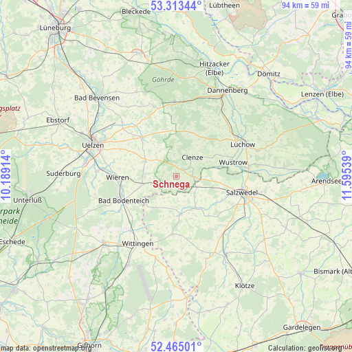
Schnega GPS coordinates[2]
52° 53' 28.68" North, 10° 53' 32.136" East
| Map corner | latitude | longitude |
|---|---|---|
| Upper-left | 53.31344°, | 10.18914° |
| Center: | 52.8913°, | 10.89226° |
| Lower-right: | 52.46501°, | 11.59539° |
| Map W x H: | 94.3×94.3 km | = 58.6×58.6mi |
| max Lat: | 55.01917° ⇑19% North |
| Schnega: | 52.8913° |
| min Lat: | ⇓81% South 47.40724° |
| min Long | Schnega | max Long |
| 5.92978° | 10.89226° | 14.98853° |
| W 65.4%⇐ | ⇒34.6% E |
Elevation
Elevation of Schnega is 40 m = 131 ft, and this is 209.1 m = 686 ft below average elevation for this country.
| Max E: |
1256 m = 4121 ft | 82.8% |
| Avg. | 249.1 m = 817 ft | |
| Schnega | 40 m = 131 ft | |
Min E: |
-5 m = -16 ft | 17.2% |
See also: Germany elevation on elevation.city.
Geographical zone
Schnega is located in North temperate zone (between Tropic of Cancer and the Arctic Circle). Distance of this North polar circle is 1520.2 km =944.6 mi to North.| Distance of | km | miles | from Schnega |
|---|---|---|---|
| North Pole | 4126.1 | 2563.8 | to North |
| Arctic Circle | 1520.2 | 944.6 | to North |
| Tropic Cancer | 3275 | 2035 | to South |
| Equator | 5881 | 3654.3 | to South |


Nearby cities:
15 places around Schnega: (largest is in red/bold)
• Bergen an der Dumme
4.3 km =2.7 mi,  90°
90°
• Bodenteich
15.6 km =9.7 mi,  244°
244°
• Clenze
6.7 km =4.2 mi,  40°
40°
• Dähre
10.4 km =6.5 mi,  174°
174°
• Henningen
7.2 km =4.5 mi,  138°
138°
• Küsten
14.9 km =9.3 mi,  49°
49°
• Luckau
11.2 km =7 mi,  69°
69°
• Osterwohle
9.9 km =6.2 mi,  128°
128°
• Rosche
14.2 km =8.8 mi,  318°
318°
• Soltendieck
9 km =5.6 mi,  257°
257°
• Suhlendorf
9.6 km =6 mi,  299°
299°
• Waddeweitz
13.1 km =8.1 mi,  22°
22°
• Wallstawe
13.1 km =8.1 mi, 140°
• Wieren
15.7 km =9.8 mi,  267°
267°
• Wustrow
16.2 km =10.1 mi,  77°
77°
Sources, notices
• [Note1] Compared only with cities in Germany existing in our database
• [Src1] Map data: © OpenStreetMap contributors (CC-BY-SA)
• [Src2] Other city data from geonames.org with taken over terms of usage.
• [Src3] Geographical zone / Annual Mean Temperature by Robert A. Rohde @ Wikipedia
