Selmsdorf geodata
Selmsdorf (Mecklenburg-Vorpommern) is a populated place; located in Germany in Europe/Berlin (GMT+2) time zone. With population of 2,261 people, there are 4724 cities with bigger population in this country. Compared to other cities in Germany, 91% of cities are located further ↓South; 64.9% of cities are located further ←West and 84.9% of cities have higher elevation than Selmsdorf. Note1
Administrative division(s):
- Level 1: Mecklenburg-Vorpommern
- Level 3: Nordwestmecklenburg
- Level 4: Selmsdorf


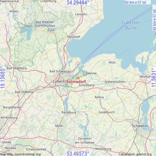
Selmsdorf GPS coordinates[2]
53° 52' 56.064" North, 10° 51' 35.892" East
| Map corner | latitude | longitude |
|---|---|---|
| Upper-left | 54.29464°, | 10.15685° |
| Center: | 53.88224°, | 10.85997° |
| Lower-right: | 53.46573°, | 11.5631° |
| Map W x H: | 92.2×92.2 km | = 57.3×57.3mi |
| max Lat: | 55.01917° ⇑9% North |
| Selmsdorf: | 53.88224° |
| min Lat: | ⇓91% South 47.40724° |
| min Long | Selmsdorf | max Long |
| 5.92978° | 10.85997° | 14.98853° |
| W 64.9%⇐ | ⇒35.1% E |
Elevation
Elevation of Selmsdorf is 35 m = 115 ft, and this is 214.1 m = 702 ft below average elevation for this country.
| Max E: |
1256 m = 4121 ft | 84.9% |
| Avg. | 249.1 m = 817 ft | |
| Selmsdorf | 35 m = 115 ft | |
Min E: |
-5 m = -16 ft | 15.1% |
See also: Germany elevation on elevation.city.
Geographical zone
Selmsdorf is located in North temperate zone (between Tropic of Cancer and the Arctic Circle). Distance of this North polar circle is 1410 km =876.1 mi to North.| Distance of | km | miles | from Selmsdorf |
|---|---|---|---|
| North Pole | 4015.9 | 2495.4 | to North |
| Arctic Circle | 1410 | 876.1 | to North |
| Tropic Cancer | 3385.2 | 2103.5 | to South |
| Equator | 5991.1 | 3722.7 | to South |


Nearby cities:
15 places around Selmsdorf: (largest is in red/bold)
• Bad Schwartau
11.4 km =7.1 mi,  290°
290°
• Carlow
14.7 km =9.1 mi,  159°
159°
• Dassow
8.2 km =5.1 mi,  67°
67°
• Groß Grönau
11.6 km =7.2 mi,  218°
218°
• Groß Sarau
15.3 km =9.5 mi,  212°
212°
• Kalkhorst
15.5 km =9.6 mi,  51°
51°
• Lübeck
11.4 km =7.1 mi,  262°
262°
• Mallentin
14.2 km =8.8 mi,  90°
90°
• Pötenitz
8.5 km =5.3 mi,  29°
29°
• Ratekau
11.2 km =7 mi,  312°
312°
• Rehna
16.9 km =10.5 mi,  132°
132°
• Schlagsdorf
16.7 km =10.4 mi,  187°
187°
• Stockelsdorf
14 km =8.7 mi,  274°
274°
• Timmendorfer Strand
13.7 km =8.5 mi,  336°
336°
• Travemünde
9 km =5.6 mi,  4°
4°
Sources, notices
• [Note1] Compared only with cities in Germany existing in our database
• [Src1] Map data: © OpenStreetMap contributors (CC-BY-SA)
• [Src2] Other city data from geonames.org with taken over terms of usage.
• [Src3] Geographical zone / Annual Mean Temperature by Robert A. Rohde @ Wikipedia
