Lübben geodata
Lübben (Brandenburg) is a seat of a third-order administrative division; located in Germany in Europe/Berlin (GMT+2) time zone. With population of 14,713 people, there are 1081 cities with bigger population in this country. Compared to other cities in Germany, 71.5% of cities are located further ↓South; 97.5% of cities are located further ←West and 77.9% of cities have higher elevation than Lübben. Note1
Administrative division(s):
- Level 1: Brandenburg
- Level 3: Landkreis Dahme-Spreewald
- Level 4: Lübben (Spreewald)


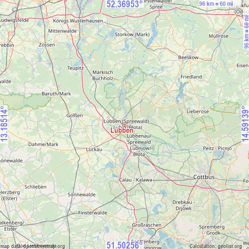
Lübben GPS coordinates[2]
51° 56' 17.304" North, 13° 53' 17.736" East
| Map corner | latitude | longitude |
|---|---|---|
| Upper-left | 52.36953°, | 13.18514° |
| Center: | 51.93814°, | 13.88826° |
| Lower-right: | 51.50256°, | 14.59139° |
| Map W x H: | 96.4×96.4 km | = 59.9×59.9mi |
| max Lat: | 55.01917° ⇑28.5% North |
| Lübben: | 51.93814° |
| min Lat: | ⇓71.5% South 47.40724° |
| min Long | Lübben | max Long |
| 5.92978° | 13.88826° | 14.98853° |
| W 97.5%⇐ | ⇒2.5% E |
Elevation
Elevation of Lübben is 53 m = 174 ft, and this is 196.1 m = 643 ft below average elevation for this country.
| Max E: |
1256 m = 4121 ft | 77.9% |
| Avg. | 249.1 m = 817 ft | |
| Lübben | 53 m = 174 ft | |
Min E: |
-5 m = -16 ft | 22.1% |
See also: Germany elevation on elevation.city.
Geographical zone
Lübben is located in North temperate zone (between Tropic of Cancer and the Arctic Circle). Distance of this North polar circle is 1626.2 km =1010.5 mi to North.| Distance of | km | miles | from Lübben |
|---|---|---|---|
| North Pole | 4232.1 | 2629.7 | to North |
| Arctic Circle | 1626.2 | 1010.5 | to North |
| Tropic Cancer | 3169.1 | 1969.2 | to South |
| Equator | 5775 | 3588.4 | to South |


Nearby cities:
15 places around Lübben: (largest is in red/bold)
• Burg
21.3 km =13.2 mi,  122°
122°
• Calau
22 km =13.7 mi,  168°
168°
• Drahnsdorf
21 km =13 mi,  263°
263°
• Golßen
20 km =12.4 mi,  280°
280°
• Halbe
23.7 km =14.7 mi,  327°
327°
• Kasel-Golzig
12.9 km =8 mi,  267°
267°
• Luckau
15.6 km =9.7 mi,  232°
232°
• Lübbenau
9.5 km =5.9 mi,  152°
152°
• Märkisch Buchholz
20.8 km =12.9 mi,  336°
336°
• Münchehofe
23.5 km =14.6 mi,  350°
350°
• Neu Zauche
13.8 km =8.6 mi,  94°
94°
• Schlepzig
10.6 km =6.6 mi,  4°
4°
• Straupitz
16.3 km =10.1 mi,  99°
99°
• Vetschau
21.4 km =13.3 mi,  142°
142°
• Werben
24.3 km =15.1 mi, 123°
Sources, notices
• [Note1] Compared only with cities in Germany existing in our database
• [Src1] Map data: © OpenStreetMap contributors (CC-BY-SA)
• [Src2] Other city data from geonames.org with taken over terms of usage.
• [Src3] Geographical zone / Annual Mean Temperature by Robert A. Rohde @ Wikipedia
