Golßen geodata
Golßen (Brandenburg) is a populated place; located in Germany in Europe/Berlin (GMT+2) time zone. With population of 2,813 people, there are 4156 cities with bigger population in this country. Compared to other cities in Germany, 71.9% of cities are located further ↓South; 96.3% of cities are located further ←West and 76.1% of cities have higher elevation than Golßen. Note1


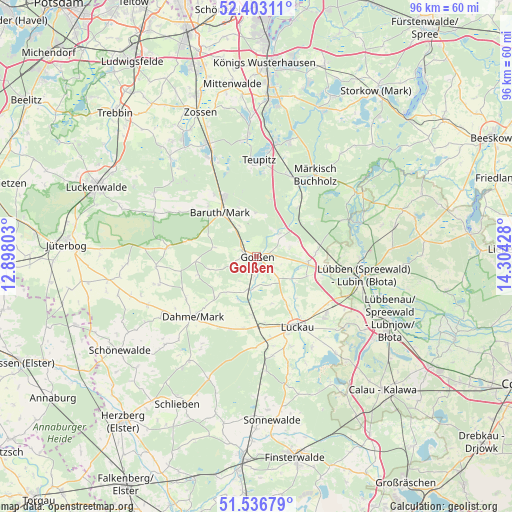
Golßen GPS coordinates[2]
51° 58' 19.344" North, 13° 36' 4.14" East
| Map corner | latitude | longitude |
|---|---|---|
| Upper-left | 52.40311°, | 12.89803° |
| Center: | 51.97204°, | 13.60115° |
| Lower-right: | 51.53679°, | 14.30428° |
| Map W x H: | 96.3×96.3 km | = 59.8×59.8mi |
| max Lat: | 55.01917° ⇑28.1% North |
| Golßen: | 51.97204° |
| min Lat: | ⇓71.9% South 47.40724° |
| min Long | Golßen | max Long |
| 5.92978° | 13.60115° | 14.98853° |
| W 96.3%⇐ | ⇒3.7% E |
Elevation
Elevation of Golßen is 59 m = 194 ft, and this is 190.1 m = 624 ft below average elevation for this country.
| Max E: |
1256 m = 4121 ft | 76.1% |
| Avg. | 249.1 m = 817 ft | |
| Golßen | 59 m = 194 ft | |
Min E: |
-5 m = -16 ft | 23.9% |
See also: Germany elevation on elevation.city.
Geographical zone
Golßen is located in North temperate zone (between Tropic of Cancer and the Arctic Circle). Distance of this North polar circle is 1622.4 km =1008.1 mi to North.| Distance of | km | miles | from Golßen |
|---|---|---|---|
| North Pole | 4228.3 | 2627.3 | to North |
| Arctic Circle | 1622.4 | 1008.1 | to North |
| Tropic Cancer | 3172.8 | 1971.5 | to South |
| Equator | 5778.7 | 3590.7 | to South |


Nearby cities:
15 places around Golßen: (largest is in red/bold)
• Baruth
10.5 km =6.5 mi,  320°
320°
• Dahme
16.4 km =10.2 mi,  226°
226°
• Drahnsdorf
6.3 km =3.9 mi,  191°
191°
• Groß Köris
21.9 km =13.6 mi,  10°
10°
• Halbe
17.4 km =10.8 mi,  22°
22°
• Hermsdorf
24.6 km =15.3 mi,  32°
32°
• Ihlow
21.5 km =13.4 mi,  237°
237°
• Kasel-Golzig
8 km =5 mi,  122°
122°
• Lebusa
23.2 km =14.4 mi,  212°
212°
• Luckau
15.2 km =9.4 mi,  151°
151°
• Lübben
20 km =12.4 mi,  100°
100°
• Märkisch Buchholz
19 km =11.8 mi,  36°
36°
• Schlepzig
21.6 km =13.4 mi,  71°
71°
• Schwerin
19.9 km =12.4 mi, 6°
• Teupitz
17.6 km =10.9 mi,  4°
4°
Sources, notices
• [Note1] Compared only with cities in Germany existing in our database
• [Src1] Map data: © OpenStreetMap contributors (CC-BY-SA)
• [Src2] Other city data from geonames.org with taken over terms of usage.
• [Src3] Geographical zone / Annual Mean Temperature by Robert A. Rohde @ Wikipedia
