Drahnsdorf geodata
Drahnsdorf (Brandenburg) is a seat of a fourth-order administrative division; located in Germany in Europe/Berlin (GMT+2) time zone. With population of 666 people, there are 8492 cities with bigger population in this country. Compared to other cities in Germany, 71.2% of cities are located further ↓South; 96.2% of cities are located further ←West and 74.5% of cities have higher elevation than Drahnsdorf. Note1
Administrative division(s):
- Level 1: Brandenburg
- Level 3: Landkreis Dahme-Spreewald
- Level 4: Drahnsdorf


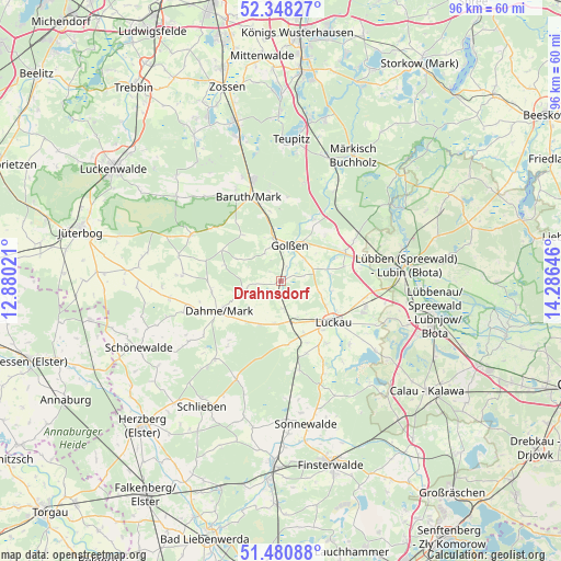
Drahnsdorf GPS coordinates[2]
51° 55' 0.012" North, 13° 34' 59.988" East
| Map corner | latitude | longitude |
|---|---|---|
| Upper-left | 52.34827°, | 12.88021° |
| Center: | 51.91667°, | 13.58333° |
| Lower-right: | 51.48088°, | 14.28646° |
| Map W x H: | 96.4×96.4 km | = 59.9×59.9mi |
| max Lat: | 55.01917° ⇑28.8% North |
| Drahnsdorf: | 51.91667° |
| min Lat: | ⇓71.2% South 47.40724° |
| min Long | Drahnsdorf | max Long |
| 5.92978° | 13.58333° | 14.98853° |
| W 96.2%⇐ | ⇒3.8% E |
Elevation
Elevation of Drahnsdorf is 65 m = 213 ft, and this is 184.1 m = 604 ft below average elevation for this country.
| Max E: |
1256 m = 4121 ft | 74.5% |
| Avg. | 249.1 m = 817 ft | |
| Drahnsdorf | 65 m = 213 ft | |
Min E: |
-5 m = -16 ft | 25.5% |
See also: Germany elevation on elevation.city.
Geographical zone
Drahnsdorf is located in North temperate zone (between Tropic of Cancer and the Arctic Circle). Distance of this North polar circle is 1628.6 km =1012 mi to North.| Distance of | km | miles | from Drahnsdorf |
|---|---|---|---|
| North Pole | 4234.5 | 2631.2 | to North |
| Arctic Circle | 1628.6 | 1012 | to North |
| Tropic Cancer | 3166.7 | 1967.7 | to South |
| Equator | 5772.6 | 3586.9 | to South |


Nearby cities:
15 places around Drahnsdorf: (largest is in red/bold)
• Baruth
15.3 km =9.5 mi,  338°
338°
• Crinitz
24 km =14.9 mi,  148°
148°
• Dahme
11.9 km =7.4 mi,  244°
244°
• Golßen
6.3 km =3.9 mi,  11°
11°
• Halbe
23.6 km =14.7 mi,  19°
19°
• Hohenbucko
18.5 km =11.5 mi,  205°
205°
• Ihlow
17.7 km =11 mi,  251°
251°
• Kasel-Golzig
8.2 km =5.1 mi,  76°
76°
• Lebusa
17.5 km =10.9 mi,  219°
219°
• Luckau
11.1 km =6.9 mi,  129°
129°
• Lübben
21 km =13 mi, 83°
• Märkisch Buchholz
24.8 km =15.4 mi,  30°
30°
• Schlepzig
25.3 km =15.7 mi,  59°
59°
• Sonnewalde
25.3 km =15.7 mi,  170°
170°
• Teupitz
23.8 km =14.8 mi, 5°
Sources, notices
• [Note1] Compared only with cities in Germany existing in our database
• [Src1] Map data: © OpenStreetMap contributors (CC-BY-SA)
• [Src2] Other city data from geonames.org with taken over terms of usage.
• [Src3] Geographical zone / Annual Mean Temperature by Robert A. Rohde @ Wikipedia
