Münchehofe geodata
Münchehofe (Brandenburg) is a seat of a fourth-order administrative division; located in Germany in Europe/Berlin (GMT+2) time zone. With population of 556 people, there are 9050 cities with bigger population in this country. Compared to other cities in Germany, 73.5% of cities are located further ↓South; 97.4% of cities are located further ←West and 81.4% of cities have higher elevation than Münchehofe. Note1
Administrative division(s):
- Level 1: Brandenburg
- Level 3: Landkreis Dahme-Spreewald
- Level 4: Münchehofe


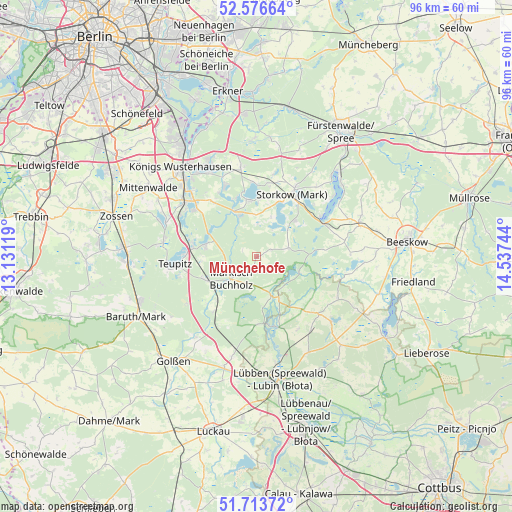
Münchehofe GPS coordinates[2]
52° 8' 50.172" North, 13° 50' 3.516" East
| Map corner | latitude | longitude |
|---|---|---|
| Upper-left | 52.57664°, | 13.13119° |
| Center: | 52.14727°, | 13.83431° |
| Lower-right: | 51.71372°, | 14.53744° |
| Map W x H: | 95.9×95.9 km | = 59.6×59.6mi |
| max Lat: | 55.01917° ⇑26.5% North |
| Münchehofe: | 52.14727° |
| min Lat: | ⇓73.5% South 47.40724° |
| min Long | Münchehofe | max Long |
| 5.92978° | 13.83431° | 14.98853° |
| W 97.4%⇐ | ⇒2.6% E |
Elevation
Elevation of Münchehofe is 43 m = 141 ft, and this is 206.1 m = 676 ft below average elevation for this country.
| Max E: |
1256 m = 4121 ft | 81.4% |
| Avg. | 249.1 m = 817 ft | |
| Münchehofe | 43 m = 141 ft | |
Min E: |
-5 m = -16 ft | 18.6% |
See also: Germany elevation on elevation.city.
Geographical zone
Münchehofe is located in North temperate zone (between Tropic of Cancer and the Arctic Circle). Distance of this North polar circle is 1602.9 km =996 mi to North.| Distance of | km | miles | from Münchehofe |
|---|---|---|---|
| North Pole | 4208.8 | 2615.2 | to North |
| Arctic Circle | 1602.9 | 996 | to North |
| Tropic Cancer | 3192.3 | 1983.6 | to South |
| Equator | 5798.2 | 3602.8 | to South |


Nearby cities:
15 places around Münchehofe: (largest is in red/bold)
• Bad Saarow
21.9 km =13.6 mi,  46°
46°
• Bestensee
16.9 km =10.5 mi,  307°
307°
• Diensdorf-Radlow
18.6 km =11.6 mi, 52°
• Groß Köris
12.1 km =7.5 mi,  279°
279°
• Halbe
9.8 km =6.1 mi,  249°
249°
• Hermsdorf
2.9 km =1.8 mi,  295°
295°
• Königs Wusterhausen
21.9 km =13.6 mi,  321°
321°
• Märkisch Buchholz
6.3 km =3.9 mi,  228°
228°
• Reichenwalde
17.4 km =10.8 mi,  40°
40°
• Schlepzig
13.4 km =8.3 mi,  160°
160°
• Schwerin
13.7 km =8.5 mi,  271°
271°
• Spreenhagen
22 km =13.7 mi,  7°
7°
• Storkow
13.9 km =8.6 mi,  29°
29°
• Teupitz
14.8 km =9.2 mi,  262°
262°
• Wendisch Rietz
14.1 km =8.8 mi,  57°
57°
Sources, notices
• [Note1] Compared only with cities in Germany existing in our database
• [Src1] Map data: © OpenStreetMap contributors (CC-BY-SA)
• [Src2] Other city data from geonames.org with taken over terms of usage.
• [Src3] Geographical zone / Annual Mean Temperature by Robert A. Rohde @ Wikipedia
