Zwönitz geodata
Zwönitz (Saxony) is a populated place; located in Germany in Europe/Berlin (GMT+2) time zone. With population of 11,547 people, there are 1427 cities with bigger population in this country. Compared to other cities in Germany, 50.2% of cities are located further ↓South; 90.8% of cities are located further ←West and 90.6% of cities have lower elevation than Zwönitz. Note1


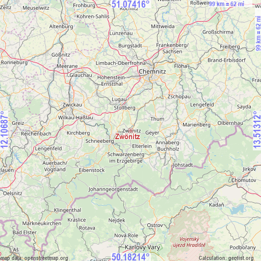
Zwönitz GPS coordinates[2]
50° 37' 48.972" North, 12° 48' 35.964" East
| Map corner | latitude | longitude |
|---|---|---|
| Upper-left | 51.07416°, | 12.10687° |
| Center: | 50.63027°, | 12.80999° |
| Lower-right: | 50.18214°, | 13.51312° |
| Map W x H: | 99.2×99.2 km | = 61.6×61.6mi |
| max Lat: | 55.01917° ⇑49.8% North |
| Zwönitz: | 50.63027° |
| min Lat: | ⇓50.2% South 47.40724° |
| min Long | Zwönitz | max Long |
| 5.92978° | 12.80999° | 14.98853° |
| W 90.8%⇐ | ⇒9.2% E |
Elevation
Elevation of Zwönitz is 521 m = 1709 ft, and this is 271.9 m = 892 ft above average elevation for this country.
| Max E: |
1256 m = 4121 ft | 9.4% |
| Zwönitz | 521 m 1709 ft | |
| Avg. | 249.1 m = 817 ft | |
Min E: |
-5 m = -16 ft | 90.6% |
See also: Germany elevation on elevation.city.
Geographical zone
Zwönitz is located in North temperate zone (between Tropic of Cancer and the Arctic Circle). Distance of this North polar circle is 1771.6 km =1100.8 mi to North.| Distance of | km | miles | from Zwönitz |
|---|---|---|---|
| North Pole | 4377.5 | 2720.1 | to North |
| Arctic Circle | 1771.6 | 1100.8 | to North |
| Tropic Cancer | 3023.6 | 1878.8 | to South |
| Equator | 5629.6 | 3498.1 | to South |


Nearby cities:
15 places around Zwönitz: (largest is in red/bold)
• Aue
8.5 km =5.3 mi,  238°
238°
• Auerbach
9.6 km =6 mi,  51°
51°
• Beierfeld
7.4 km =4.6 mi,  190°
190°
• Bernsbach
6.7 km =4.2 mi,  206°
206°
• Dorfchemnitz
4.2 km =2.6 mi,  26°
26°
• Elterlein
7.2 km =4.5 mi,  145°
145°
• Geyer
7.8 km =4.8 mi,  93°
93°
• Gornsdorf
9.3 km =5.8 mi, 33°
• Grünhain
5.6 km =3.5 mi,  182°
182°
• Hormersdorf
7 km =4.3 mi, 46°
• Lauter
9.2 km =5.7 mi,  215°
215°
• Lößnitz
5.6 km =3.5 mi,  260°
260°
• Stollberg
9.1 km =5.7 mi,  346°
346°
• Tannenberg
9.4 km =5.8 mi,  105°
105°
• Thalheim
8.3 km =5.2 mi,  19°
19°
Sources, notices
• [Note1] Compared only with cities in Germany existing in our database
• [Src1] Map data: © OpenStreetMap contributors (CC-BY-SA)
• [Src2] Other city data from geonames.org with taken over terms of usage.
• [Src3] Geographical zone / Annual Mean Temperature by Robert A. Rohde @ Wikipedia
