Lonnig geodata
Lonnig (Rheinland-Pfalz) is a seat of a fourth-order administrative division; located in Germany in Europe/Berlin (GMT+2) time zone. With population of 1,170 people, there are 6646 cities with bigger population in this country. Compared to other cities in Germany, 56.6% of cities are located further ↑North; 88.5% of cities are located further →East and 53.6% of cities have lower elevation than Lonnig. Note1
Administrative division(s):
- Level 1: Rheinland-Pfalz
- Level 3: Landkreis Mayen-Koblenz
- Level 4: Lonnig


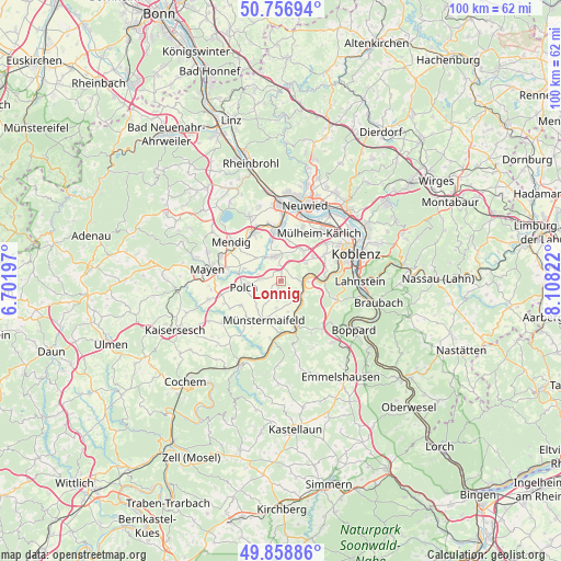
Lonnig GPS coordinates[2]
50° 18' 36.072" North, 7° 24' 18.324" East
| Map corner | latitude | longitude |
|---|---|---|
| Upper-left | 50.75694°, | 6.70197° |
| Center: | 50.31002°, | 7.40509° |
| Lower-right: | 49.85886°, | 8.10822° |
| Map W x H: | 99.9×99.9 km | = 62.1×62.1mi |
| max Lat: | 55.01917° ⇑56.6% North |
| Lonnig: | 50.31002° |
| min Lat: | ⇓43.4% South 47.40724° |
| min Long | Lonnig | max Long |
| 5.92978° | 7.40509° | 14.98853° |
| W 11.5%⇐ | ⇒88.5% E |
Elevation
Elevation of Lonnig is 250 m = 820 ft, and this is 0.90000000000001 m = 3 ft above average elevation for this country.
| Max E: |
1256 m = 4121 ft | 46.4% |
| Lonnig | 250 m 820 ft | |
| Avg. | 249.1 m = 817 ft | |
Min E: |
-5 m = -16 ft | 53.6% |
See also: Germany elevation on elevation.city.
Geographical zone
Lonnig is located in North temperate zone (between Tropic of Cancer and the Arctic Circle). Distance of this North polar circle is 1807.2 km =1122.9 mi to North.| Distance of | km | miles | from Lonnig |
|---|---|---|---|
| North Pole | 4413.1 | 2742.2 | to North |
| Arctic Circle | 1807.2 | 1122.9 | to North |
| Tropic Cancer | 2988 | 1856.7 | to South |
| Equator | 5593.9 | 3475.9 | to South |


Nearby cities:
15 places around Lonnig: (largest is in red/bold)
• Bassenheim
6.6 km =4.1 mi,  35°
35°
• Dieblich
4.8 km =3 mi,  84°
84°
• Gappenach
5.9 km =3.7 mi,  226°
226°
• Gierschnach
6.2 km =3.9 mi,  219°
219°
• Kalt
4.8 km =3 mi,  188°
188°
• Kerben
2.8 km =1.7 mi,  285°
285°
• Kobern-Gondorf
3.7 km =2.3 mi,  103°
103°
• Lehmen
4.4 km =2.7 mi,  132°
132°
• Niederfell
5.3 km =3.3 mi,  124°
124°
• Oberfell
6.2 km =3.9 mi,  153°
153°
• Ochtendung
4.7 km =2.9 mi,  340°
340°
• Polch
6.6 km =4.1 mi,  260°
260°
• Rüber
2.9 km =1.8 mi,  247°
247°
• Welling
6.8 km =4.2 mi, 292°
• Wolken
5.1 km =3.2 mi,  59°
59°
Sources, notices
• [Note1] Compared only with cities in Germany existing in our database
• [Src1] Map data: © OpenStreetMap contributors (CC-BY-SA)
• [Src2] Other city data from geonames.org with taken over terms of usage.
• [Src3] Geographical zone / Annual Mean Temperature by Robert A. Rohde @ Wikipedia
