Bassenheim geodata
Bassenheim (Rheinland-Pfalz) is a seat of a fourth-order administrative division; located in Germany in Europe/Berlin (GMT+2) time zone. With population of 2,787 people, there are 4170 cities with bigger population in this country. Compared to other cities in Germany, 55.4% of cities are located further ↑North; 87.8% of cities are located further →East and 57.2% of cities have higher elevation than Bassenheim. Note1
Administrative division(s):
- Level 1: Rheinland-Pfalz
- Level 3: Landkreis Mayen-Koblenz
- Level 4: Bassenheim


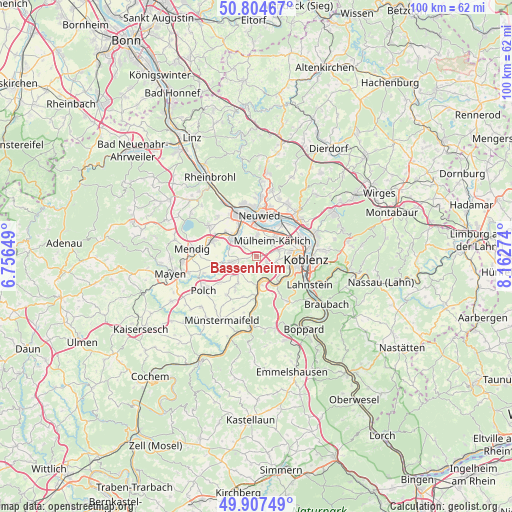
Bassenheim GPS coordinates[2]
50° 21' 29.52" North, 7° 27' 34.596" East
| Map corner | latitude | longitude |
|---|---|---|
| Upper-left | 50.80467°, | 6.75649° |
| Center: | 50.3582°, | 7.45961° |
| Lower-right: | 49.90749°, | 8.16274° |
| Map W x H: | 99.8×99.8 km | = 62×62mi |
| max Lat: | 55.01917° ⇑55.4% North |
| Bassenheim: | 50.3582° |
| min Lat: | ⇓44.6% South 47.40724° |
| min Long | Bassenheim | max Long |
| 5.92978° | 7.45961° | 14.98853° |
| W 12.2%⇐ | ⇒87.8% E |
Elevation
Elevation of Bassenheim is 173 m = 568 ft, and this is 76.1 m = 250 ft below average elevation for this country.
| Max E: |
1256 m = 4121 ft | 57.2% |
| Avg. | 249.1 m = 817 ft | |
| Bassenheim | 173 m = 568 ft | |
Min E: |
-5 m = -16 ft | 42.8% |
See also: Germany elevation on elevation.city.
Geographical zone
Bassenheim is located in North temperate zone (between Tropic of Cancer and the Arctic Circle). Distance of this North polar circle is 1801.9 km =1119.6 mi to North.| Distance of | km | miles | from Bassenheim |
|---|---|---|---|
| North Pole | 4407.8 | 2738.9 | to North |
| Arctic Circle | 1801.9 | 1119.6 | to North |
| Tropic Cancer | 2993.4 | 1860 | to South |
| Equator | 5599.3 | 3479.2 | to South |


Nearby cities:
15 places around Bassenheim: (largest is in red/bold)
• Dieblich
5 km =3.1 mi,  169°
169°
• Kerben
8.1 km =5 mi,  235°
235°
• Kettig
4.7 km =2.9 mi,  6°
6°
• Kobern-Gondorf
6.2 km =3.9 mi,  182°
182°
• Kretz
8.1 km =5 mi,  301°
301°
• Lonnig
6.6 km =4.1 mi,  215°
215°
• Mülheim-Kärlich
4.1 km =2.5 mi,  42°
42°
• Niederfell
8.3 km =5.2 mi, 176°
• Ochtendung
5.5 km =3.4 mi,  260°
260°
• Plaidt
6.1 km =3.8 mi,  308°
308°
• Saffig
4.1 km =2.5 mi, 312°
• Urmitz
7.7 km =4.8 mi,  31°
31°
• Weißenthurm
6.6 km =4.1 mi,  354°
354°
• Winningen
6.1 km =3.8 mi,  138°
138°
• Wolken
2.8 km =1.7 mi, 169°
Sources, notices
• [Note1] Compared only with cities in Germany existing in our database
• [Src1] Map data: © OpenStreetMap contributors (CC-BY-SA)
• [Src2] Other city data from geonames.org with taken over terms of usage.
• [Src3] Geographical zone / Annual Mean Temperature by Robert A. Rohde @ Wikipedia
