Langenwolschendorf geodata
Langenwolschendorf (Thuringia) is a seat of a fourth-order administrative division; located in Germany in Europe/Berlin (GMT+2) time zone. With population of 949 people, there are 7350 cities with bigger population in this country. Compared to other cities in Germany, 50.4% of cities are located further ↓South; 81.2% of cities are located further ←West and 81.4% of cities have lower elevation than Langenwolschendorf. Note1


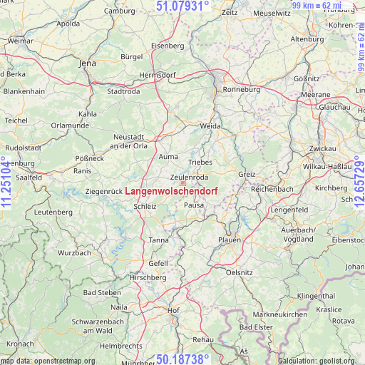
Langenwolschendorf GPS coordinates[2]
50° 38' 7.656" North, 11° 57' 14.976" East
| Map corner | latitude | longitude |
|---|---|---|
| Upper-left | 51.07931°, | 11.25104° |
| Center: | 50.63546°, | 11.95416° |
| Lower-right: | 50.18738°, | 12.65729° |
| Map W x H: | 99.2×99.2 km | = 61.6×61.6mi |
| max Lat: | 55.01917° ⇑49.6% North |
| Langenwolschendorf: | 50.63546° |
| min Lat: | ⇓50.4% South 47.40724° |
| min Long | Langenwolschend | max Long |
| 5.92978° | 11.95416° | 14.98853° |
| W 81.2%⇐ | ⇒18.8% E |
Elevation
Elevation of Langenwolschendorf is 443 m = 1453 ft, and this is 193.9 m = 636 ft above average elevation for this country.
| Max E: |
1256 m = 4121 ft | 18.6% |
| Langenwolschendorf | 443 m 1453 ft | |
| Avg. | 249.1 m = 817 ft | |
Min E: |
-5 m = -16 ft | 81.4% |
See also: Germany elevation on elevation.city.
Geographical zone
Langenwolschendorf is located in North temperate zone (between Tropic of Cancer and the Arctic Circle). Distance of this North polar circle is 1771 km =1100.4 mi to North.| Distance of | km | miles | from Langenwolschendorf |
|---|---|---|---|
| North Pole | 4376.9 | 2719.7 | to North |
| Arctic Circle | 1771 | 1100.4 | to North |
| Tropic Cancer | 3024.2 | 1879.2 | to South |
| Equator | 5630.1 | 3498.4 | to South |


Nearby cities:
15 places around Langenwolschendorf: (largest is in red/bold)
• Auma
8.2 km =5.1 mi,  331°
331°
• Chursdorf
8.1 km =5 mi,  295°
295°
• Dittersdorf
9.8 km =6.1 mi,  279°
279°
• Göschitz
6.2 km =3.9 mi,  267°
267°
• Kirschkau
5.8 km =3.6 mi,  234°
234°
• Löhma
7.7 km =4.8 mi,  249°
249°
• Mühltroff
10.9 km =6.8 mi,  189°
189°
• Oettersdorf
10.5 km =6.5 mi, 247°
• Pausa
6.7 km =4.2 mi,  152°
152°
• Pörmitz
9.9 km =6.2 mi,  257°
257°
• Reinsdorf
8.9 km =5.5 mi, 304°
• Tegau
6.4 km =4 mi, 284°
• Triebes
7.2 km =4.5 mi,  40°
40°
• Weißendorf
6.2 km =3.9 mi,  31°
31°
• Zeulenroda
2.8 km =1.7 mi,  47°
47°
Sources, notices
• [Note1] Compared only with cities in Germany existing in our database
• [Src1] Map data: © OpenStreetMap contributors (CC-BY-SA)
• [Src2] Other city data from geonames.org with taken over terms of usage.
• [Src3] Geographical zone / Annual Mean Temperature by Robert A. Rohde @ Wikipedia
