Tegau geodata
Tegau (Thuringia) is a seat of a fourth-order administrative division; located in Germany in Europe/Berlin (GMT+2) time zone. With population of 426 people, there are 9618 cities with bigger population in this country. Compared to other cities in Germany, 50.7% of cities are located further ↓South; 79.7% of cities are located further ←West and 83% of cities have lower elevation than Tegau. Note1


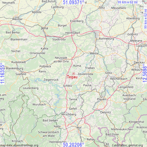
Tegau GPS coordinates[2]
50° 39' 0" North, 11° 52' 0.012" East
| Map corner | latitude | longitude |
|---|---|---|
| Upper-left | 51.09371°, | 11.16355° |
| Center: | 50.65°, | 11.86667° |
| Lower-right: | 50.20206°, | 12.5698° |
| Map W x H: | 99.1×99.1 km | = 61.6×61.6mi |
| max Lat: | 55.01917° ⇑49.3% North |
| Tegau: | 50.65° |
| min Lat: | ⇓50.7% South 47.40724° |
| min Long | Tegau | max Long |
| 5.92978° | 11.86667° | 14.98853° |
| W 79.7%⇐ | ⇒20.3% E |
Elevation
Elevation of Tegau is 453 m = 1486 ft, and this is 203.9 m = 669 ft above average elevation for this country.
| Max E: |
1256 m = 4121 ft | 17% |
| Tegau | 453 m 1486 ft | |
| Avg. | 249.1 m = 817 ft | |
Min E: |
-5 m = -16 ft | 83% |
See also: Germany elevation on elevation.city.
Geographical zone
Tegau is located in North temperate zone (between Tropic of Cancer and the Arctic Circle). Distance of this North polar circle is 1769.4 km =1099.5 mi to North.| Distance of | km | miles | from Tegau |
|---|---|---|---|
| North Pole | 4375.3 | 2718.7 | to North |
| Arctic Circle | 1769.4 | 1099.5 | to North |
| Tropic Cancer | 3025.8 | 1880.1 | to South |
| Equator | 5631.8 | 3499.4 | to South |


Nearby cities:
15 places around Tegau: (largest is in red/bold)
• Auma
6.1 km =3.8 mi,  22°
22°
• Chursdorf
2.2 km =1.4 mi,  327°
327°
• Dittersdorf
3.5 km =2.2 mi,  270°
270°
• Göschitz
1.9 km =1.2 mi,  180°
180°
• Kirschkau
5.2 km =3.2 mi,  163°
163°
• Langenwolschendorf
6.4 km =4 mi,  104°
104°
• Lemnitz
8.3 km =5.2 mi,  343°
343°
• Löhma
4.4 km =2.7 mi,  193°
193°
• Moßbach
5.1 km =3.2 mi,  316°
316°
• Oettersdorf
6.6 km =4.1 mi,  212°
212°
• Plothen
7.3 km =4.5 mi,  255°
255°
• Pörmitz
5.1 km =3.2 mi,  223°
223°
• Reinsdorf
3.5 km =2.2 mi, 340°
• Tömmelsdorf
7.4 km =4.6 mi,  0°
0°
• Zeulenroda
8.3 km =5.2 mi,  87°
87°
Sources, notices
• [Note1] Compared only with cities in Germany existing in our database
• [Src1] Map data: © OpenStreetMap contributors (CC-BY-SA)
• [Src2] Other city data from geonames.org with taken over terms of usage.
• [Src3] Geographical zone / Annual Mean Temperature by Robert A. Rohde @ Wikipedia
