Lindau geodata
Lindau (Saxony-Anhalt) is a populated place; located in Germany in Europe/Berlin (GMT+2) time zone. With population of 1,207 people, there are 6545 cities with bigger population in this country. Compared to other cities in Germany, 72.4% of cities are located further ↓South; 83.3% of cities are located further ←West and 71.7% of cities have higher elevation than Lindau. Note1


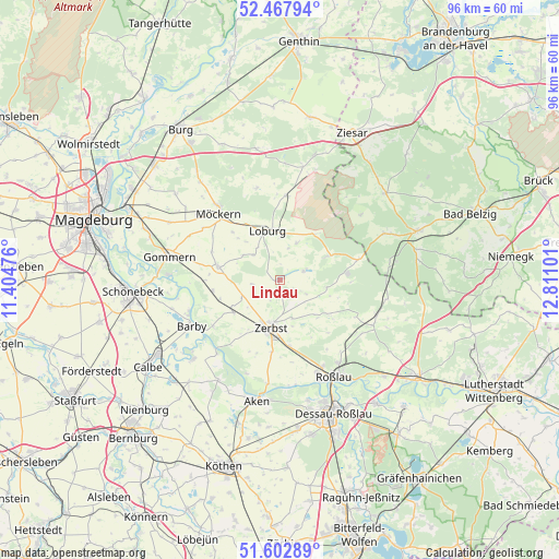
Lindau GPS coordinates[2]
52° 2' 15.036" North, 12° 6' 28.368" East
| Map corner | latitude | longitude |
|---|---|---|
| Upper-left | 52.46794°, | 11.40476° |
| Center: | 52.03751°, | 12.10788° |
| Lower-right: | 51.60289°, | 12.81101° |
| Map W x H: | 96.2×96.2 km | = 59.8×59.8mi |
| max Lat: | 55.01917° ⇑27.6% North |
| Lindau: | 52.03751° |
| min Lat: | ⇓72.4% South 47.40724° |
| min Long | Lindau | max Long |
| 5.92978° | 12.10788° | 14.98853° |
| W 83.3%⇐ | ⇒16.7% E |
Elevation
Elevation of Lindau is 80 m = 262 ft, and this is 169.1 m = 555 ft below average elevation for this country.
| Max E: |
1256 m = 4121 ft | 71.7% |
| Avg. | 249.1 m = 817 ft | |
| Lindau | 80 m = 262 ft | |
Min E: |
-5 m = -16 ft | 28.3% |
See also: Germany elevation on elevation.city.
Geographical zone
Lindau is located in North temperate zone (between Tropic of Cancer and the Arctic Circle). Distance of this North polar circle is 1615.1 km =1003.6 mi to North.| Distance of | km | miles | from Lindau |
|---|---|---|---|
| North Pole | 4221 | 2622.8 | to North |
| Arctic Circle | 1615.1 | 1003.6 | to North |
| Tropic Cancer | 3180.1 | 1976 | to South |
| Equator | 5786 | 3595.3 | to South |


Nearby cities:
15 places around Lindau: (largest is in red/bold)
• Bornum
9.2 km =5.7 mi,  134°
134°
• Breitenhagen
16.7 km =10.4 mi,  220°
220°
• Dannigkow
16.4 km =10.2 mi,  282°
282°
• Deetz
4.4 km =2.7 mi,  69°
69°
• Güterglück
9.7 km =6 mi,  235°
235°
• Hohenziatz
16.5 km =10.3 mi,  346°
346°
• Jütrichau
11.3 km =7 mi,  172°
172°
• Leitzkau
10.9 km =6.8 mi, 282°
• Loburg
8.9 km =5.5 mi, 346°
• Möckern
15.7 km =9.8 mi,  317°
317°
• Rosian
7.1 km =4.4 mi,  24°
24°
• Thießen
15.9 km =9.9 mi,  124°
124°
• Walternienburg
13.9 km =8.6 mi, 235°
• Zeppernick
11.4 km =7.1 mi,  329°
329°
• Zerbst
8.1 km =5 mi,  191°
191°
Sources, notices
• [Note1] Compared only with cities in Germany existing in our database
• [Src1] Map data: © OpenStreetMap contributors (CC-BY-SA)
• [Src2] Other city data from geonames.org with taken over terms of usage.
• [Src3] Geographical zone / Annual Mean Temperature by Robert A. Rohde @ Wikipedia
