Limburgerhof geodata
Limburgerhof (Rheinland-Pfalz) is a seat of a fourth-order administrative division; located in Germany in Europe/Berlin (GMT+2) time zone. With population of 10,753 people, there are 1539 cities with bigger population in this country. Compared to other cities in Germany, 76.9% of cities are located further ↑North; 72% of cities are located further →East and 68.7% of cities have higher elevation than Limburgerhof. Note1
Administrative division(s):
- Level 1: Rheinland-Pfalz
- Level 3: Rhein-Pfalz-Kreis
- Level 4: Limburgerhof


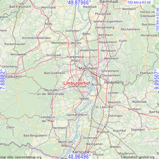
Limburgerhof GPS coordinates[2]
49° 25' 27.984" North, 8° 23' 30.984" East
| Map corner | latitude | longitude |
|---|---|---|
| Upper-left | 49.87966°, | 7.68882° |
| Center: | 49.42444°, | 8.39194° |
| Lower-right: | 48.96496°, | 9.09507° |
| Map W x H: | 101.7×101.7 km | = 63.2×63.2mi |
| max Lat: | 55.01917° ⇑76.9% North |
| Limburgerhof: | 49.42444° |
| min Lat: | ⇓23.1% South 47.40724° |
| min Long | Limburgerhof | max Long |
| 5.92978° | 8.39194° | 14.98853° |
| W 28%⇐ | ⇒72% E |
Elevation
Elevation of Limburgerhof is 99 m = 325 ft, and this is 150.1 m = 492 ft below average elevation for this country.
| Max E: |
1256 m = 4121 ft | 68.7% |
| Avg. | 249.1 m = 817 ft | |
| Limburgerhof | 99 m = 325 ft | |
Min E: |
-5 m = -16 ft | 31.3% |
See also: Germany elevation on elevation.city.
Geographical zone
Limburgerhof is located in North temperate zone (between Tropic of Cancer and the Arctic Circle). Distance of this North polar circle is 1905.7 km =1184.1 mi to North.| Distance of | km | miles | from Limburgerhof |
|---|---|---|---|
| North Pole | 4511.6 | 2803.4 | to North |
| Arctic Circle | 1905.7 | 1184.1 | to North |
| Tropic Cancer | 2889.6 | 1795.5 | to South |
| Equator | 5495.5 | 3414.7 | to South |


Nearby cities:
15 places around Limburgerhof: (largest is in red/bold)
• Altrip
7.5 km =4.7 mi,  80°
80°
• Böhl-Iggelheim
8 km =5 mi,  232°
232°
• Dannstadt-Schauernheim
6.3 km =3.9 mi,  286°
286°
• Fußgönheim
8.3 km =5.2 mi,  299°
299°
• Gartenstadt
4 km =2.5 mi,  12°
12°
• Hochdorf-Assenheim
8 km =5 mi,  266°
266°
• Ludwigshafen am Rhein
7.4 km =4.6 mi,  31°
31°
• Mannheim
9 km =5.6 mi,  37°
37°
• Maxdorf
10.1 km =6.3 mi,  314°
314°
• Mutterstadt
3.2 km =2 mi, 306°
• Neuhofen
2.4 km =1.5 mi, 81°
• Otterstadt
7.1 km =4.4 mi,  145°
145°
• Rödersheim-Gronau
9.5 km =5.9 mi, 273°
• Schifferstadt
4.6 km =2.9 mi,  193°
193°
• Waldsee
4.8 km =3 mi,  132°
132°
Sources, notices
• [Note1] Compared only with cities in Germany existing in our database
• [Src1] Map data: © OpenStreetMap contributors (CC-BY-SA)
• [Src2] Other city data from geonames.org with taken over terms of usage.
• [Src3] Geographical zone / Annual Mean Temperature by Robert A. Rohde @ Wikipedia
