Maxdorf geodata
Maxdorf (Rheinland-Pfalz) is a seat of a fourth-order administrative division; located in Germany in Europe/Berlin (GMT+2) time zone. With population of 6,882 people, there are 2206 cities with bigger population in this country. Compared to other cities in Germany, 75.9% of cities are located further ↑North; 73% of cities are located further →East and 69.4% of cities have higher elevation than Maxdorf. Note1


Maxdorf GPS coordinates[2]
49° 29' 17.016" North, 8° 17' 30.012" East
| Map corner | latitude | longitude |
|---|---|---|
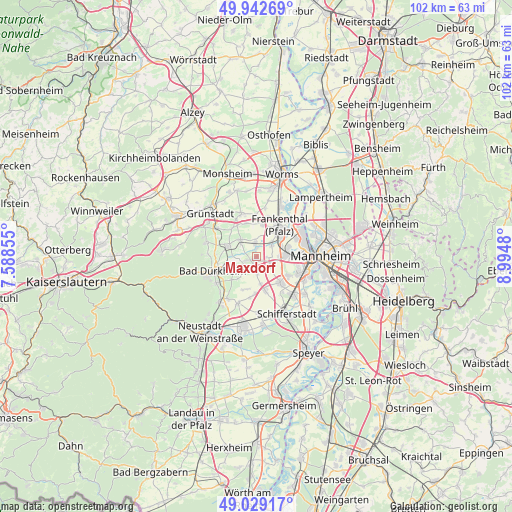
| Upper-left | 49.94269°, | 7.58855° |
| Center: | 49.48806°, | 8.29167° |
| Lower-right: | 49.02917°, | 8.9948° |
| Map W x H: | 101.6×101.6 km | = 63.1×63.1mi |
| max Lat: | 55.01917° ⇑75.9% North |
| Maxdorf: | 49.48806° |
| min Lat: | ⇓24.1% South 47.40724° |
| min Long | Maxdorf | max Long |
| 5.92978° | 8.29167° | 14.98853° |
| W 27%⇐ | ⇒73% E |
Elevation
Elevation of Maxdorf is 95 m = 312 ft, and this is 154.1 m = 506 ft below average elevation for this country.
| Max E: |
1256 m = 4121 ft | 69.4% |
| Avg. | 249.1 m = 817 ft | |
| Maxdorf | 95 m = 312 ft | |
Min E: |
-5 m = -16 ft | 30.6% |
See also: Germany elevation on elevation.city.
Geographical zone
Maxdorf is located in North temperate zone (between Tropic of Cancer and the Arctic Circle). Distance of this North polar circle is 1898.6 km =1179.7 mi to North.| Distance of | km | miles | from Maxdorf |
|---|---|---|---|
| North Pole | 4504.5 | 2799 | to North |
| Arctic Circle | 1898.6 | 1179.7 | to North |
| Tropic Cancer | 2896.6 | 1799.9 | to South |
| Equator | 5502.6 | 3419.2 | to South |


Nearby cities:
15 places around Maxdorf: (largest is in red/bold)
• Birkenheide
2.3 km =1.4 mi,  250°
250°
• Dannstadt-Schauernheim
5.5 km =3.4 mi,  167°
167°
• Ellerstadt
3.7 km =2.3 mi,  218°
218°
• Erpolzheim
4.8 km =3 mi,  271°
271°
• Frankenthal
6.8 km =4.2 mi,  41°
41°
• Freinsheim
6.1 km =3.8 mi,  289°
289°
• Friedelsheim
6.7 km =4.2 mi,  227°
227°
• Fußgönheim
3 km =1.9 mi,  179°
179°
• Gerolsheim
6.9 km =4.3 mi,  343°
343°
• Gönnheim
5.9 km =3.7 mi, 220°
• Heßheim
6.5 km =4 mi,  10°
10°
• Lambsheim
2.9 km =1.8 mi,  354°
354°
• Mutterstadt
7 km =4.3 mi,  138°
138°
• Rödersheim-Gronau
6.8 km =4.2 mi,  198°
198°
• Weisenheim am Sand
4.6 km =2.9 mi,  316°
316°
Sources, notices
• [Note1] Compared only with cities in Germany existing in our database
• [Src1] Map data: © OpenStreetMap contributors (CC-BY-SA)
• [Src2] Other city data from geonames.org with taken over terms of usage.
• [Src3] Geographical zone / Annual Mean Temperature by Robert A. Rohde @ Wikipedia
