Rödersheim-Gronau geodata
Rödersheim-Gronau (Rheinland-Pfalz) is a seat of a fourth-order administrative division; located in Germany in Europe/Berlin (GMT+2) time zone. With population of 2,903 people, there are 4090 cities with bigger population in this country. Compared to other cities in Germany, 76.8% of cities are located further ↑North; 73.3% of cities are located further →East and 67.1% of cities have higher elevation than Rödersheim-Gronau. Note1
Administrative division(s):
- Level 1: Rheinland-Pfalz
- Level 3: Rhein-Pfalz-Kreis
- Level 4: Rödersheim-Gronau


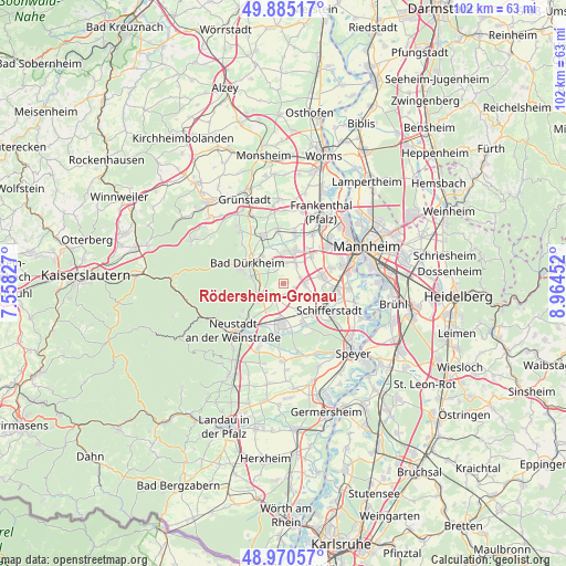
Rödersheim-Gronau GPS coordinates[2]
49° 25' 48" North, 8° 15' 41.004" East
| Map corner | latitude | longitude |
|---|---|---|
| Upper-left | 49.88517°, | 7.55827° |
| Center: | 49.43°, | 8.26139° |
| Lower-right: | 48.97057°, | 8.96452° |
| Map W x H: | 101.7×101.7 km | = 63.2×63.2mi |
| max Lat: | 55.01917° ⇑76.8% North |
| Rödersheim-Gronau: | 49.43° |
| min Lat: | ⇓23.2% South 47.40724° |
| min Long | Rödersheim-Gro | max Long |
| 5.92978° | 8.26139° | 14.98853° |
| W 26.7%⇐ | ⇒73.3% E |
Elevation
Elevation of Rödersheim-Gronau is 107 m = 351 ft, and this is 142.1 m = 466 ft below average elevation for this country.
| Max E: |
1256 m = 4121 ft | 67.1% |
| Avg. | 249.1 m = 817 ft | |
| Rödersheim-Gronau | 107 m = 351 ft | |
Min E: |
-5 m = -16 ft | 32.9% |
See also: Germany elevation on elevation.city.
Geographical zone
Rödersheim-Gronau is located in North temperate zone (between Tropic of Cancer and the Arctic Circle). Distance of this North polar circle is 1905.1 km =1183.8 mi to North.| Distance of | km | miles | from Rödersheim-Gronau |
|---|---|---|---|
| North Pole | 4511 | 2803 | to North |
| Arctic Circle | 1905.1 | 1183.8 | to North |
| Tropic Cancer | 2890.2 | 1795.9 | to South |
| Equator | 5496.1 | 3415.1 | to South |


Nearby cities:
15 places around Rödersheim-Gronau: (largest is in red/bold)
• Birkenheide
5.7 km =3.5 mi,  0°
0°
• Böhl-Iggelheim
6.3 km =3.9 mi,  150°
150°
• Dannstadt-Schauernheim
3.6 km =2.2 mi,  71°
71°
• Deidesheim
6.1 km =3.8 mi,  246°
246°
• Ellerstadt
3.5 km =2.2 mi,  357°
357°
• Forst
5.2 km =3.2 mi,  264°
264°
• Friedelsheim
3.4 km =2.1 mi,  304°
304°
• Fußgönheim
4.1 km =2.5 mi,  32°
32°
• Gönnheim
2.6 km =1.6 mi,  320°
320°
• Hochdorf-Assenheim
1.9 km =1.2 mi,  128°
128°
• Maxdorf
6.8 km =4.2 mi,  18°
18°
• Meckenheim
3.3 km =2.1 mi,  209°
209°
• Niederkirchen bei Deidesheim
4.1 km =2.5 mi, 245°
• Ruppertsberg
5.8 km =3.6 mi,  235°
235°
• Wachenheim
6 km =3.7 mi,  281°
281°
Sources, notices
• [Note1] Compared only with cities in Germany existing in our database
• [Src1] Map data: © OpenStreetMap contributors (CC-BY-SA)
• [Src2] Other city data from geonames.org with taken over terms of usage.
• [Src3] Geographical zone / Annual Mean Temperature by Robert A. Rohde @ Wikipedia
