Böhl-Iggelheim geodata
Böhl-Iggelheim (Rheinland-Pfalz) is a seat of a fourth-order administrative division; located in Germany in Europe/Berlin (GMT+2) time zone. With population of 10,797 people, there are 1531 cities with bigger population in this country. Compared to other cities in Germany, 77.5% of cities are located further ↑North; 72.9% of cities are located further →East and 67% of cities have higher elevation than Böhl-Iggelheim. Note1
Administrative division(s):
- Level 1: Rheinland-Pfalz
- Level 3: Rhein-Pfalz-Kreis
- Level 4: Böhl-Iggelheim


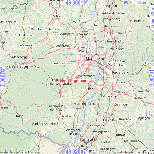
Böhl-Iggelheim GPS coordinates[2]
49° 22' 50.016" North, 8° 18' 14.004" East
| Map corner | latitude | longitude |
|---|---|---|
| Upper-left | 49.83619°, | 7.60076° |
| Center: | 49.38056°, | 8.30389° |
| Lower-right: | 48.92067°, | 9.00701° |
| Map W x H: | 101.8×101.8 km | = 63.3×63.3mi |
| max Lat: | 55.01917° ⇑77.5% North |
| Böhl-Iggelheim: | 49.38056° |
| min Lat: | ⇓22.5% South 47.40724° |
| min Long | Böhl-Iggelheim | max Long |
| 5.92978° | 8.30389° | 14.98853° |
| W 27.1%⇐ | ⇒72.9% E |
Elevation
Elevation of Böhl-Iggelheim is 108 m = 354 ft, and this is 141.1 m = 463 ft below average elevation for this country.
| Max E: |
1256 m = 4121 ft | 67% |
| Avg. | 249.1 m = 817 ft | |
| Böhl-Iggelheim | 108 m = 354 ft | |
Min E: |
-5 m = -16 ft | 33% |
See also: Germany elevation on elevation.city.
Geographical zone
Böhl-Iggelheim is located in North temperate zone (between Tropic of Cancer and the Arctic Circle). Distance of this North polar circle is 1910.6 km =1187.2 mi to North.| Distance of | km | miles | from Böhl-Iggelheim |
|---|---|---|---|
| North Pole | 4516.5 | 2806.4 | to North |
| Arctic Circle | 1910.6 | 1187.2 | to North |
| Tropic Cancer | 2884.7 | 1792.5 | to South |
| Equator | 5490.6 | 3411.7 | to South |


Nearby cities:
15 places around Böhl-Iggelheim: (largest is in red/bold)
• Dannstadt-Schauernheim
6.6 km =4.1 mi,  2°
2°
• Deidesheim
9.2 km =5.7 mi,  289°
289°
• Dudenhofen
9.2 km =5.7 mi,  138°
138°
• Fußgönheim
9 km =5.6 mi,  354°
354°
• Gönnheim
8.9 km =5.5 mi,  327°
327°
• Hanhofen
7.6 km =4.7 mi,  159°
159°
• Haßloch
3.9 km =2.4 mi,  239°
239°
• Hochdorf-Assenheim
4.6 km =2.9 mi,  339°
339°
• Limburgerhof
8 km =5 mi,  52°
52°
• Meckenheim
5.4 km =3.4 mi,  299°
299°
• Mutterstadt
7.7 km =4.8 mi,  29°
29°
• Niederkirchen bei Deidesheim
7.8 km =4.8 mi, 299°
• Ruppertsberg
8.1 km =5 mi, 285°
• Rödersheim-Gronau
6.3 km =3.9 mi, 330°
• Schifferstadt
5.3 km =3.3 mi,  85°
85°
Sources, notices
• [Note1] Compared only with cities in Germany existing in our database
• [Src1] Map data: © OpenStreetMap contributors (CC-BY-SA)
• [Src2] Other city data from geonames.org with taken over terms of usage.
• [Src3] Geographical zone / Annual Mean Temperature by Robert A. Rohde @ Wikipedia
