Lichtenstein geodata
Lichtenstein (Saxony) is a populated place; located in Germany in Europe/Berlin (GMT+2) time zone. With population of 13,612 people, there are 1179 cities with bigger population in this country. Compared to other cities in Germany, 53.4% of cities are located further ↓South; 89.2% of cities are located further ←West and 62.9% of cities have lower elevation than Lichtenstein. Note1


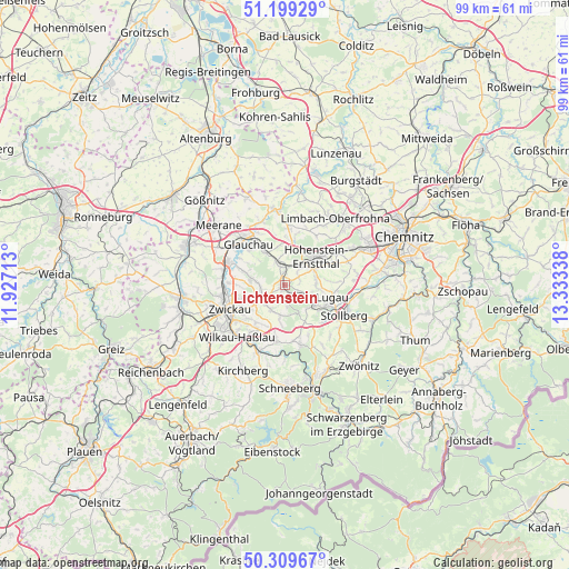
Lichtenstein GPS coordinates[2]
50° 45' 23.724" North, 12° 37' 48.9" East
| Map corner | latitude | longitude |
|---|---|---|
| Upper-left | 51.19929°, | 11.92713° |
| Center: | 50.75659°, | 12.63025° |
| Lower-right: | 50.30967°, | 13.33338° |
| Map W x H: | 98.9×98.9 km | = 61.5×61.5mi |
| max Lat: | 55.01917° ⇑46.6% North |
| Lichtenstein: | 50.75659° |
| min Lat: | ⇓53.4% South 47.40724° |
| min Long | Lichtenstein | max Long |
| 5.92978° | 12.63025° | 14.98853° |
| W 89.2%⇐ | ⇒10.8% E |
Elevation
Elevation of Lichtenstein is 308 m = 1010 ft, and this is 58.9 m = 193 ft above average elevation for this country.
| Max E: |
1256 m = 4121 ft | 37.1% |
| Lichtenstein | 308 m 1010 ft | |
| Avg. | 249.1 m = 817 ft | |
Min E: |
-5 m = -16 ft | 62.9% |
See also: Germany elevation on elevation.city.
Geographical zone
Lichtenstein is located in North temperate zone (between Tropic of Cancer and the Arctic Circle). Distance of this North polar circle is 1757.6 km =1092.1 mi to North.| Distance of | km | miles | from Lichtenstein |
|---|---|---|---|
| North Pole | 4363.5 | 2711.4 | to North |
| Arctic Circle | 1757.6 | 1092.1 | to North |
| Tropic Cancer | 3037.7 | 1887.5 | to South |
| Equator | 5643.6 | 3506.8 | to South |


Nearby cities:
15 places around Lichtenstein: (largest is in red/bold)
• Bernsdorf
2.8 km =1.7 mi,  66°
66°
• Callenberg
10.4 km =6.5 mi,  1°
1°
• Gersdorf
6.1 km =3.8 mi,  96°
96°
• Glauchau
9.2 km =5.7 mi,  319°
319°
• Hohenstein-Ernstthal
7.6 km =4.7 mi,  49°
49°
• Hohndorf
4 km =2.5 mi,  116°
116°
• Kirchberg
9.5 km =5.9 mi,  86°
86°
• Lugau
8.6 km =5.3 mi, 103°
• Mülsen
4.5 km =2.8 mi,  260°
260°
• Oberlungwitz
6.2 km =3.9 mi,  62°
62°
• Oelsnitz
6 km =3.7 mi, 124°
• Reinsdorf
8.4 km =5.2 mi,  218°
218°
• Sankt Egidien
3.3 km =2.1 mi,  352°
352°
• Wildenfels
10 km =6.2 mi,  188°
188°
• Zwickau
10.5 km =6.5 mi,  251°
251°
Sources, notices
• [Note1] Compared only with cities in Germany existing in our database
• [Src1] Map data: © OpenStreetMap contributors (CC-BY-SA)
• [Src2] Other city data from geonames.org with taken over terms of usage.
• [Src3] Geographical zone / Annual Mean Temperature by Robert A. Rohde @ Wikipedia
