Lichte geodata
Lichte (Thuringia) is a seat of a fourth-order administrative division; located in Germany in Europe/Berlin (GMT+2) time zone. With population of 1,906 people, there are 5195 cities with bigger population in this country. Compared to other cities in Germany, 52.5% of cities are located further ↑North; 69.7% of cities are located further ←West and 96.7% of cities have lower elevation than Lichte. Note1
Administrative division(s):
- Level 1: Thuringia
- Level 3: Landkreis Sonneberg
- Level 4: Neuhaus am Rennweg


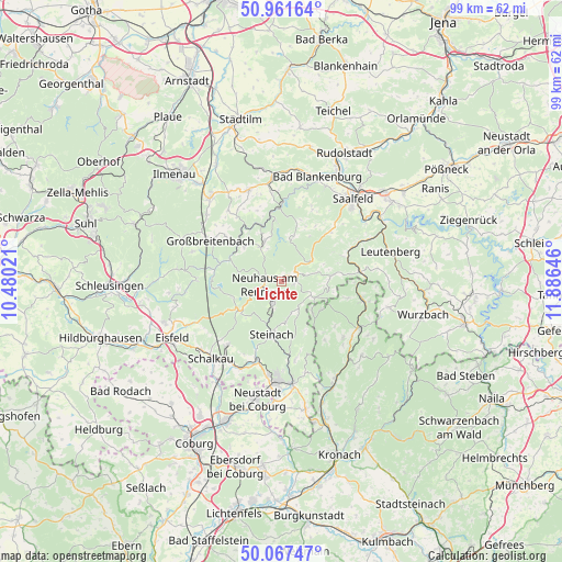
Lichte GPS coordinates[2]
50° 31' 0.012" North, 11° 10' 59.988" East
| Map corner | latitude | longitude |
|---|---|---|
| Upper-left | 50.96164°, | 10.48021° |
| Center: | 50.51667°, | 11.18333° |
| Lower-right: | 50.06747°, | 11.88646° |
| Map W x H: | 99.4×99.4 km | = 61.8×61.8mi |
| max Lat: | 55.01917° ⇑52.5% North |
| Lichte: | 50.51667° |
| min Lat: | ⇓47.5% South 47.40724° |
| min Long | Lichte | max Long |
| 5.92978° | 11.18333° | 14.98853° |
| W 69.7%⇐ | ⇒30.3% E |
Elevation
Elevation of Lichte is 652 m = 2139 ft, and this is 402.9 m = 1322 ft above average elevation for this country.
| Max E: |
1256 m = 4121 ft | 3.3% |
| Lichte | 652 m 2139 ft | |
| Avg. | 249.1 m = 817 ft | |
Min E: |
-5 m = -16 ft | 96.7% |
See also: Germany elevation on elevation.city.
Geographical zone
Lichte is located in North temperate zone (between Tropic of Cancer and the Arctic Circle). Distance of this North polar circle is 1784.2 km =1108.7 mi to North.| Distance of | km | miles | from Lichte |
|---|---|---|---|
| North Pole | 4390.1 | 2727.9 | to North |
| Arctic Circle | 1784.2 | 1108.7 | to North |
| Tropic Cancer | 3011 | 1870.9 | to South |
| Equator | 5616.9 | 3490.2 | to South |


Nearby cities:
15 places around Lichte: (largest is in red/bold)
• Cursdorf
6.6 km =4.1 mi,  327°
327°
• Deesbach
6 km =3.7 mi,  337°
337°
• Lauscha
4.7 km =2.9 mi,  200°
200°
• Meura
7.5 km =4.7 mi,  9°
9°
• Meuselbach
8.9 km =5.5 mi,  313°
313°
• Neuhaus am Rennweg
3.3 km =2.1 mi,  257°
257°
• Oberweißbach
7.8 km =4.8 mi, 339°
• Piesau
2.4 km =1.5 mi,  90°
90°
• Reichmannsdorf
6.4 km =4 mi,  55°
55°
• Rohrbach
9.6 km =6 mi, 14°
• Scheibe-Alsbach
9.1 km =5.7 mi,  249°
249°
• Schmiedefeld
3 km =1.9 mi,  51°
51°
• Steinach
9.6 km =6 mi,  190°
190°
• Steinheid
9.1 km =5.7 mi,  231°
231°
• Tettau
7.5 km =4.7 mi,  134°
134°
Sources, notices
• [Note1] Compared only with cities in Germany existing in our database
• [Src1] Map data: © OpenStreetMap contributors (CC-BY-SA)
• [Src2] Other city data from geonames.org with taken over terms of usage.
• [Src3] Geographical zone / Annual Mean Temperature by Robert A. Rohde @ Wikipedia
