Steinach geodata
Steinach (Thuringia) is a populated place; located in Germany in Europe/Berlin (GMT+2) time zone. With population of 4,729 people, there are 2933 cities with bigger population in this country. Compared to other cities in Germany, 54.1% of cities are located further ↑North; 69.3% of cities are located further ←West and 87.8% of cities have lower elevation than Steinach. Note1


Steinach GPS coordinates[2]
50° 25' 52.644" North, 11° 9' 32.724" East
| Map corner | latitude | longitude |
|---|---|---|
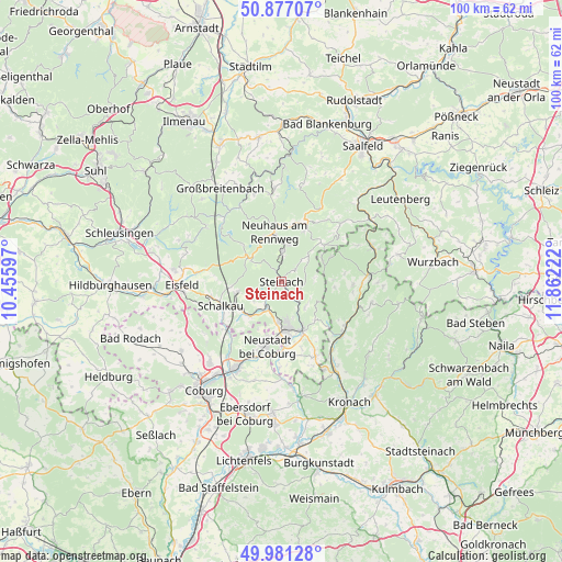
| Upper-left | 50.87707°, | 10.45597° |
| Center: | 50.43129°, | 11.15909° |
| Lower-right: | 49.98128°, | 11.86222° |
| Map W x H: | 99.6×99.6 km | = 61.9×61.9mi |
| max Lat: | 55.01917° ⇑54.1% North |
| Steinach: | 50.43129° |
| min Lat: | ⇓45.9% South 47.40724° |
| min Long | Steinach | max Long |
| 5.92978° | 11.15909° | 14.98853° |
| W 69.3%⇐ | ⇒30.7% E |
Elevation
Elevation of Steinach is 492 m = 1614 ft, and this is 242.9 m = 797 ft above average elevation for this country.
| Max E: |
1256 m = 4121 ft | 12.2% |
| Steinach | 492 m 1614 ft | |
| Avg. | 249.1 m = 817 ft | |
Min E: |
-5 m = -16 ft | 87.8% |
See also: Germany elevation on elevation.city.
Geographical zone
Steinach is located in North temperate zone (between Tropic of Cancer and the Arctic Circle). Distance of this North polar circle is 1793.7 km =1114.6 mi to North.| Distance of | km | miles | from Steinach |
|---|---|---|---|
| North Pole | 4399.6 | 2733.8 | to North |
| Arctic Circle | 1793.7 | 1114.6 | to North |
| Tropic Cancer | 3001.5 | 1865 | to South |
| Equator | 5607.4 | 3484.3 | to South |


Nearby cities:
15 places around Steinach: (largest is in red/bold)
• Ebersdorf
11.4 km =7.1 mi,  182°
182°
• Föritz
11.2 km =7 mi,  152°
152°
• Judenbach
5.9 km =3.7 mi,  131°
131°
• Lauscha
5.1 km =3.2 mi,  0°
0°
• Lichte
9.6 km =6 mi,  10°
10°
• Mengersgereuth-Hämmern
4.8 km =3 mi,  218°
218°
• Neuhaus am Rennweg
8.9 km =5.5 mi,  350°
350°
• Neustadt bei Coburg
11.6 km =7.2 mi,  193°
193°
• Piesau
10.3 km =6.4 mi,  23°
23°
• Schalkau
11.5 km =7.1 mi,  249°
249°
• Scheibe-Alsbach
9.3 km =5.8 mi,  312°
312°
• Schmiedefeld
12.1 km =7.5 mi, 19°
• Sonneberg
8.1 km =5 mi,  172°
172°
• Steinheid
6.6 km =4.1 mi, 305°
• Tettau
8.3 km =5.2 mi,  58°
58°
Sources, notices
• [Note1] Compared only with cities in Germany existing in our database
• [Src1] Map data: © OpenStreetMap contributors (CC-BY-SA)
• [Src2] Other city data from geonames.org with taken over terms of usage.
• [Src3] Geographical zone / Annual Mean Temperature by Robert A. Rohde @ Wikipedia
