Steinheid geodata
Steinheid (Thuringia) is a populated place; located in Germany in Europe/Berlin (GMT+2) time zone. With population of 1,311 people, there are 6275 cities with bigger population in this country. Compared to other cities in Germany, 53.5% of cities are located further ↑North; 68.1% of cities are located further ←West and 99.3% of cities have lower elevation than Steinheid. Note1
Administrative division(s):
- Level 1: Thuringia
- Level 3: Landkreis Sonneberg
- Level 4: Neuhaus am Rennweg


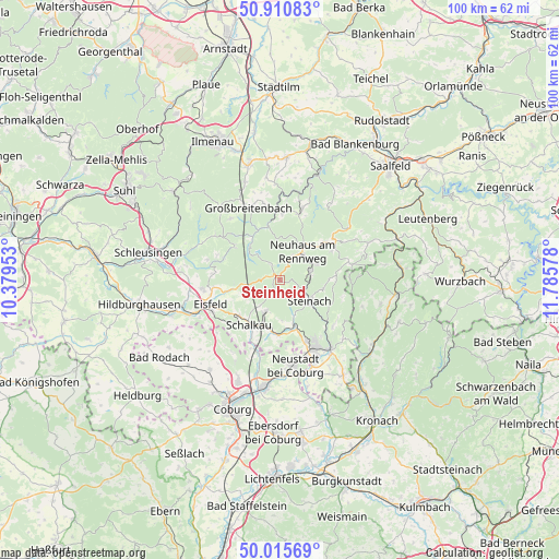
Steinheid GPS coordinates[2]
50° 27' 55.368" North, 11° 4' 57.54" East
| Map corner | latitude | longitude |
|---|---|---|
| Upper-left | 50.91083°, | 10.37953° |
| Center: | 50.46538°, | 11.08265° |
| Lower-right: | 50.01569°, | 11.78578° |
| Map W x H: | 99.5×99.5 km | = 61.8×61.8mi |
| max Lat: | 55.01917° ⇑53.5% North |
| Steinheid: | 50.46538° |
| min Lat: | ⇓46.5% South 47.40724° |
| min Long | Steinheid | max Long |
| 5.92978° | 11.08265° | 14.98853° |
| W 68.1%⇐ | ⇒31.9% E |
Elevation
Elevation of Steinheid is 807 m = 2648 ft, and this is 557.9 m = 1830 ft above average elevation for this country.
| Max E: |
1256 m = 4121 ft | 0.7% |
| Steinheid | 807 m 2648 ft | |
| Avg. | 249.1 m = 817 ft | |
Min E: |
-5 m = -16 ft | 99.3% |
See also: Germany elevation on elevation.city.
Geographical zone
Steinheid is located in North temperate zone (between Tropic of Cancer and the Arctic Circle). Distance of this North polar circle is 1789.9 km =1112.2 mi to North.| Distance of | km | miles | from Steinheid |
|---|---|---|---|
| North Pole | 4395.8 | 2731.4 | to North |
| Arctic Circle | 1789.9 | 1112.2 | to North |
| Tropic Cancer | 3005.3 | 1867.4 | to South |
| Equator | 5611.2 | 3486.6 | to South |


Nearby cities:
15 places around Steinheid: (largest is in red/bold)
• Bachfeld
8.9 km =5.5 mi,  232°
232°
• Cursdorf
11.8 km =7.3 mi,  17°
17°
• Goldisthal
8.2 km =5.1 mi,  314°
314°
• Katzhütte
9.8 km =6.1 mi,  347°
347°
• Lauscha
5.6 km =3.5 mi,  76°
76°
• Lichte
9.1 km =5.7 mi,  51°
51°
• Masserberg
10 km =6.2 mi, 307°
• Mengersgereuth-Hämmern
7.9 km =4.9 mi,  162°
162°
• Meuselbach
11.8 km =7.3 mi,  3°
3°
• Neuhaus am Rennweg
6.3 km =3.9 mi,  38°
38°
• Piesau
11.1 km =6.9 mi,  58°
58°
• Sachsenbrunn
9.6 km =6 mi,  257°
257°
• Schalkau
9.4 km =5.8 mi,  214°
214°
• Scheibe-Alsbach
2.9 km =1.8 mi,  329°
329°
• Steinach
6.6 km =4.1 mi,  125°
125°
Sources, notices
• [Note1] Compared only with cities in Germany existing in our database
• [Src1] Map data: © OpenStreetMap contributors (CC-BY-SA)
• [Src2] Other city data from geonames.org with taken over terms of usage.
• [Src3] Geographical zone / Annual Mean Temperature by Robert A. Rohde @ Wikipedia
