Leupoldsgrün geodata
Leupoldsgrün (Bavaria) is a seat of a fourth-order administrative division; located in Germany in Europe/Berlin (GMT+2) time zone. With population of 1,382 people, there are 6114 cities with bigger population in this country. Compared to other cities in Germany, 56.8% of cities are located further ↑North; 78.8% of cities are located further ←West and 96.1% of cities have lower elevation than Leupoldsgrün. Note1
Administrative division(s):
- Level 1: Bavaria
- Level 2: Upper Franconia
- Level 3: Landkreis Hof
- Level 4: Leupoldsgrün


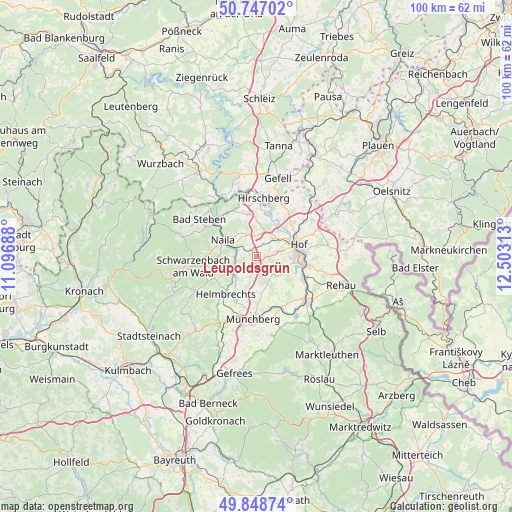
Leupoldsgrün GPS coordinates[2]
50° 18' 0" North, 11° 48' 0" East
| Map corner | latitude | longitude |
|---|---|---|
| Upper-left | 50.74702°, | 11.09688° |
| Center: | 50.3°, | 11.8° |
| Lower-right: | 49.84874°, | 12.50313° |
| Map W x H: | 99.9×99.9 km | = 62.1×62.1mi |
| max Lat: | 55.01917° ⇑56.8% North |
| Leupoldsgrün: | 50.3° |
| min Lat: | ⇓43.2% South 47.40724° |
| min Long | Leupoldsgrün | max Long |
| 5.92978° | 11.8° | 14.98853° |
| W 78.8%⇐ | ⇒21.2% E |
Elevation
Elevation of Leupoldsgrün is 631 m = 2070 ft, and this is 381.9 m = 1253 ft above average elevation for this country.
| Max E: |
1256 m = 4121 ft | 3.9% |
| Leupoldsgrün | 631 m 2070 ft | |
| Avg. | 249.1 m = 817 ft | |
Min E: |
-5 m = -16 ft | 96.1% |
See also: Germany elevation on elevation.city.
Geographical zone
Leupoldsgrün is located in North temperate zone (between Tropic of Cancer and the Arctic Circle). Distance of this North polar circle is 1808.3 km =1123.6 mi to North.| Distance of | km | miles | from Leupoldsgrün |
|---|---|---|---|
| North Pole | 4414.2 | 2742.9 | to North |
| Arctic Circle | 1808.3 | 1123.6 | to North |
| Tropic Cancer | 2986.9 | 1856 | to South |
| Equator | 5592.8 | 3475.2 | to South |


Nearby cities:
15 places around Leupoldsgrün: (largest is in red/bold)
• Berg
8.4 km =5.2 mi,  349°
349°
• Döhlau
10.8 km =6.7 mi,  99°
99°
• Feilitzsch
12 km =7.5 mi,  51°
51°
• Helmbrechts
9.3 km =5.8 mi,  219°
219°
• Hof
8.1 km =5 mi,  79°
79°
• Issigau
10.1 km =6.3 mi,  326°
326°
• Konradsreuth
5.1 km =3.2 mi,  136°
136°
• Köditz
5.1 km =3.2 mi,  43°
43°
• Lichtenberg
12.8 km =8 mi,  316°
316°
• Münchberg
12.3 km =7.6 mi,  183°
183°
• Naila
7.6 km =4.7 mi,  296°
296°
• Oberkotzau
10.5 km =6.5 mi,  113°
113°
• Schauenstein
4.8 km =3 mi,  239°
239°
• Selbitz
4 km =2.5 mi, 298°
• Töpen
11.3 km =7 mi,  27°
27°
Sources, notices
• [Note1] Compared only with cities in Germany existing in our database
• [Src1] Map data: © OpenStreetMap contributors (CC-BY-SA)
• [Src2] Other city data from geonames.org with taken over terms of usage.
• [Src3] Geographical zone / Annual Mean Temperature by Robert A. Rohde @ Wikipedia
