Döhlau geodata
Döhlau (Bavaria) is a seat of a fourth-order administrative division; located in Germany in Europe/Berlin (GMT+2) time zone. With population of 4,235 people, there are 3163 cities with bigger population in this country. Compared to other cities in Germany, 57.2% of cities are located further ↑North; 81.1% of cities are located further ←West and 90.7% of cities have lower elevation than Döhlau. Note1
Administrative division(s):
- Level 1: Bavaria
- Level 2: Upper Franconia
- Level 3: Landkreis Hof
- Level 4: Döhlau


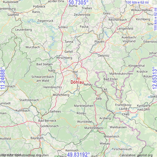
Döhlau GPS coordinates[2]
50° 16' 59.988" North, 11° 57' 0" East
| Map corner | latitude | longitude |
|---|---|---|
| Upper-left | 50.7305°, | 11.24688° |
| Center: | 50.28333°, | 11.95° |
| Lower-right: | 49.83192°, | 12.65313° |
| Map W x H: | 99.9×99.9 km | = 62.1×62.1mi |
| max Lat: | 55.01917° ⇑57.2% North |
| Döhlau: | 50.28333° |
| min Lat: | ⇓42.8% South 47.40724° |
| min Long | Döhlau | max Long |
| 5.92978° | 11.95° | 14.98853° |
| W 81.1%⇐ | ⇒18.9% E |
Elevation
Elevation of Döhlau is 523 m = 1716 ft, and this is 273.9 m = 899 ft above average elevation for this country.
| Max E: |
1256 m = 4121 ft | 9.3% |
| Döhlau | 523 m 1716 ft | |
| Avg. | 249.1 m = 817 ft | |
Min E: |
-5 m = -16 ft | 90.7% |
See also: Germany elevation on elevation.city.
Geographical zone
Döhlau is located in North temperate zone (between Tropic of Cancer and the Arctic Circle). Distance of this North polar circle is 1810.2 km =1124.8 mi to North.| Distance of | km | miles | from Döhlau |
|---|---|---|---|
| North Pole | 4416.1 | 2744 | to North |
| Arctic Circle | 1810.2 | 1124.8 | to North |
| Tropic Cancer | 2985.1 | 1854.9 | to South |
| Equator | 5591 | 3474.1 | to South |


Nearby cities:
15 places around Döhlau: (largest is in red/bold)
• Feilitzsch
9.3 km =5.8 mi,  352°
352°
• Gattendorf
5.5 km =3.4 mi,  38°
38°
• Haag
9.2 km =5.7 mi,  75°
75°
• Hof
4.2 km =2.6 mi,  321°
321°
• Konradsreuth
7.3 km =4.5 mi,  255°
255°
• Köditz
9 km =5.6 mi,  308°
308°
• Leupoldsgrün
10.8 km =6.7 mi,  279°
279°
• Oberkotzau
2.6 km =1.6 mi,  204°
204°
• Regnitzlosau
7.3 km =4.5 mi, 75°
• Rehau
7.1 km =4.4 mi,  122°
122°
• Schwarzenbach an der Saale
6.8 km =4.2 mi,  188°
188°
• Schönwald
13.4 km =8.3 mi,  134°
134°
• Trogen
9.3 km =5.8 mi,  0°
0°
• Töpen
13.1 km =8.1 mi,  335°
335°
• Weißdorf
13.2 km =8.2 mi,  212°
212°
Sources, notices
• [Note1] Compared only with cities in Germany existing in our database
• [Src1] Map data: © OpenStreetMap contributors (CC-BY-SA)
• [Src2] Other city data from geonames.org with taken over terms of usage.
• [Src3] Geographical zone / Annual Mean Temperature by Robert A. Rohde @ Wikipedia
