Töpen geodata
Töpen (Bavaria) is a seat of a fourth-order administrative division; located in Germany in Europe/Berlin (GMT+2) time zone. With population of 1,175 people, there are 6636 cities with bigger population in this country. Compared to other cities in Germany, 54.8% of cities are located further ↑North; 79.9% of cities are located further ←West and 90.8% of cities have lower elevation than Töpen. Note1
Administrative division(s):
- Level 1: Bavaria
- Level 2: Upper Franconia
- Level 3: Landkreis Hof
- Level 4: Töpen


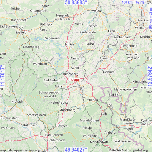
Töpen GPS coordinates[2]
50° 23' 26.412" North, 11° 52' 23.844" East
| Map corner | latitude | longitude |
|---|---|---|
| Upper-left | 50.83683°, | 11.17017° |
| Center: | 50.39067°, | 11.87329° |
| Lower-right: | 49.94027°, | 12.57642° |
| Map W x H: | 99.7×99.7 km | = 62×62mi |
| max Lat: | 55.01917° ⇑54.8% North |
| Töpen: | 50.39067° |
| min Lat: | ⇓45.2% South 47.40724° |
| min Long | Töpen | max Long |
| 5.92978° | 11.87329° | 14.98853° |
| W 79.9%⇐ | ⇒20.1% E |
Elevation
Elevation of Töpen is 525 m = 1722 ft, and this is 275.9 m = 905 ft above average elevation for this country.
| Max E: |
1256 m = 4121 ft | 9.2% |
| Töpen | 525 m 1722 ft | |
| Avg. | 249.1 m = 817 ft | |
Min E: |
-5 m = -16 ft | 90.8% |
See also: Germany elevation on elevation.city.
Geographical zone
Töpen is located in North temperate zone (between Tropic of Cancer and the Arctic Circle). Distance of this North polar circle is 1798.3 km =1117.4 mi to North.| Distance of | km | miles | from Töpen |
|---|---|---|---|
| North Pole | 4404.1 | 2736.6 | to North |
| Arctic Circle | 1798.3 | 1117.4 | to North |
| Tropic Cancer | 2997 | 1862.2 | to South |
| Equator | 5602.9 | 3481.5 | to South |


Nearby cities:
15 places around Töpen: (largest is in red/bold)
• Berg
7 km =4.3 mi,  255°
255°
• Birkenhügel
9.9 km =6.2 mi,  298°
298°
• Blankenberg
11.2 km =7 mi,  277°
277°
• Blankenstein
12.4 km =7.7 mi, 275°
• Feilitzsch
5 km =3.1 mi,  122°
122°
• Gattendorf
11.7 km =7.3 mi,  130°
130°
• Hof
9.1 km =5.7 mi,  162°
162°
• Issigau
11 km =6.8 mi, 260°
• Köditz
6.6 km =4.1 mi,  194°
194°
• Leupoldsgrün
11.3 km =7 mi,  207°
207°
• Pottiga
9.8 km =6.1 mi,  285°
285°
• Reuth
10.7 km =6.6 mi,  34°
34°
• Selbitz
12 km =7.5 mi,  226°
226°
• Tanna
11.6 km =7.2 mi,  354°
354°
• Trogen
6.1 km =3.8 mi, 116°
Sources, notices
• [Note1] Compared only with cities in Germany existing in our database
• [Src1] Map data: © OpenStreetMap contributors (CC-BY-SA)
• [Src2] Other city data from geonames.org with taken over terms of usage.
• [Src3] Geographical zone / Annual Mean Temperature by Robert A. Rohde @ Wikipedia
