Leienkaul geodata
Leienkaul (Rheinland-Pfalz) is a seat of a fourth-order administrative division; located in Germany in Europe/Berlin (GMT+2) time zone. In our database, there are 11009 cities with bigger population. Compared to other cities in Germany, 58.8% of cities are located further ↑North; 92.5% of cities are located further →East and 84.8% of cities have lower elevation than Leienkaul. Note1
Administrative division(s):
- Level 1: Rheinland-Pfalz
- Level 3: Landkreis Cochem-Zell
- Level 4: Leienkaul


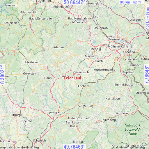
Leienkaul GPS coordinates[2]
50° 13' 0.012" North, 7° 4' 59.988" East
| Map corner | latitude | longitude |
|---|---|---|
| Upper-left | 50.66447°, | 6.38021° |
| Center: | 50.21667°, | 7.08333° |
| Lower-right: | 49.76463°, | 7.78646° |
| Map W x H: | 100.1×100.1 km | = 62.2×62.2mi |
| max Lat: | 55.01917° ⇑58.8% North |
| Leienkaul: | 50.21667° |
| min Lat: | ⇓41.2% South 47.40724° |
| min Long | Leienkaul | max Long |
| 5.92978° | 7.08333° | 14.98853° |
| W 7.5%⇐ | ⇒92.5% E |
Elevation
Elevation of Leienkaul is 467 m = 1532 ft, and this is 217.9 m = 715 ft above average elevation for this country.
| Max E: |
1256 m = 4121 ft | 15.2% |
| Leienkaul | 467 m 1532 ft | |
| Avg. | 249.1 m = 817 ft | |
Min E: |
-5 m = -16 ft | 84.8% |
See also: Germany elevation on elevation.city.
Geographical zone
Leienkaul is located in North temperate zone (between Tropic of Cancer and the Arctic Circle). Distance of this North polar circle is 1817.6 km =1129.4 mi to North.| Distance of | km | miles | from Leienkaul |
|---|---|---|---|
| North Pole | 4423.5 | 2748.6 | to North |
| Arctic Circle | 1817.6 | 1129.4 | to North |
| Tropic Cancer | 2977.7 | 1850.3 | to South |
| Equator | 5583.6 | 3469.5 | to South |


Nearby cities:
15 places around Leienkaul: (largest is in red/bold)
• Alflen
5.4 km =3.4 mi,  215°
215°
• Büchel
4.9 km =3 mi,  180°
180°
• Eppenberg
3.9 km =2.4 mi,  342°
342°
• Greimersburg
5.1 km =3.2 mi,  136°
136°
• Hauroth
3.9 km =2.4 mi,  17°
17°
• Kaisersesch
4.3 km =2.7 mi,  67°
67°
• Kalenborn
5.6 km =3.5 mi,  0°
0°
• Kaperich
5.1 km =3.2 mi,  316°
316°
• Landkern
5.6 km =3.5 mi,  116°
116°
• Laubach
1.9 km =1.2 mi, 338°
• Lirstal
5.1 km =3.2 mi, 316°
• Masburg
3.6 km =2.2 mi,  42°
42°
• Müllenbach
1.3 km =0.8 mi,  293°
293°
• Uersfeld
6 km =3.7 mi,  308°
308°
• Urmersbach
5.1 km =3.2 mi, 43°
Sources, notices
• [Note1] Compared only with cities in Germany existing in our database
• [Src1] Map data: © OpenStreetMap contributors (CC-BY-SA)
• [Src2] Other city data from geonames.org with taken over terms of usage.
• [Src3] Geographical zone / Annual Mean Temperature by Robert A. Rohde @ Wikipedia
