Castrop-Rauxel geodata
Castrop-Rauxel (North Rhine-Westphalia) is a populated place; located in Germany in Europe/Berlin (GMT+2) time zone. With population of 77,924 people, there are 129 cities with bigger population in this country. Compared to other cities in Germany, 67% of cities are located further ↓South; 89.8% of cities are located further →East and 71.2% of cities have higher elevation than Castrop-Rauxel. Note1
Administrative division(s):
- Level 1: North Rhine-Westphalia
- Level 2: Regierungsbezirk Münster
- Level 3: Kreis Recklinghausen
- Level 4: Castrop-Rauxel


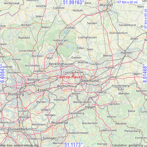
Castrop-Rauxel GPS coordinates[2]
51° 33' 23.652" North, 7° 18' 41.58" East
| Map corner | latitude | longitude |
|---|---|---|
| Upper-left | 51.99163°, | 6.60843° |
| Center: | 51.55657°, | 7.31155° |
| Lower-right: | 51.1173°, | 8.01468° |
| Map W x H: | 97.2×97.2 km | = 60.4×60.4mi |
| max Lat: | 55.01917° ⇑33% North |
| Castrop-Rauxel: | 51.55657° |
| min Lat: | ⇓67% South 47.40724° |
| min Long | Castrop-Rauxel | max Long |
| 5.92978° | 7.31155° | 14.98853° |
| W 10.2%⇐ | ⇒89.8% E |
Elevation
Elevation of Castrop-Rauxel is 83 m = 272 ft, and this is 166.1 m = 545 ft below average elevation for this country.
| Max E: |
1256 m = 4121 ft | 71.2% |
| Avg. | 249.1 m = 817 ft | |
| Castrop-Rauxel | 83 m = 272 ft | |
Min E: |
-5 m = -16 ft | 28.8% |
See also: Castrop-Rauxel elevation on elevation.city.
Geographical zone
Castrop-Rauxel is located in North temperate zone (between Tropic of Cancer and the Arctic Circle). Distance of this North polar circle is 1668.6 km =1036.8 mi to North.| Distance of | km | miles | from Castrop-Rauxel |
|---|---|---|---|
| North Pole | 4274.5 | 2656.1 | to North |
| Arctic Circle | 1668.6 | 1036.8 | to North |
| Tropic Cancer | 3126.6 | 1942.8 | to South |
| Equator | 5732.6 | 3562.1 | to South |


Nearby cities:
15 places around Castrop-Rauxel: (largest is in red/bold)
• Bochum
10.6 km =6.6 mi,  218°
218°
• Bochum-Hordel
11.2 km =7 mi,  237°
237°
• Datteln
11.3 km =7 mi,  11°
11°
• Dortmund
11.6 km =7.2 mi,  113°
113°
• Gelsenkirchen
15.9 km =9.9 mi,  248°
248°
• Herne
6.3 km =3.9 mi, 251°
• Herten
12.4 km =7.7 mi,  290°
290°
• Hordel
11.4 km =7.1 mi, 235°
• Lanstrop
17.8 km =11.1 mi,  83°
83°
• Lünen
16.4 km =10.2 mi,  66°
66°
• Oer-Erkenschwick
10 km =6.2 mi,  341°
341°
• Olfen
17.5 km =10.9 mi,  15°
15°
• Recklinghausen
10.1 km =6.3 mi,  308°
308°
• Waltrop
9.5 km =5.9 mi,  41°
41°
• Witten
12.9 km =8 mi,  167°
167°
Sources, notices
• [Note1] Compared only with cities in Germany existing in our database
• [Src1] Map data: © OpenStreetMap contributors (CC-BY-SA)
• [Src2] Other city data from geonames.org with taken over terms of usage.
• [Src3] Geographical zone / Annual Mean Temperature by Robert A. Rohde @ Wikipedia
