Kupferzell geodata
Kupferzell (Baden-Württemberg) is a seat of a fourth-order administrative division; located in Germany in Europe/Berlin (GMT+2) time zone. With population of 5,736 people, there are 2550 cities with bigger population in this country. Compared to other cities in Germany, 80% of cities are located further ↑North; 54.5% of cities are located further →East and 66.7% of cities have lower elevation than Kupferzell. Note1
Administrative division(s):
- Level 1: Baden-Württemberg
- Level 2: Regierungsbezirk Stuttgart
- Level 3: Hohenlohekreis
- Level 4: Kupferzell


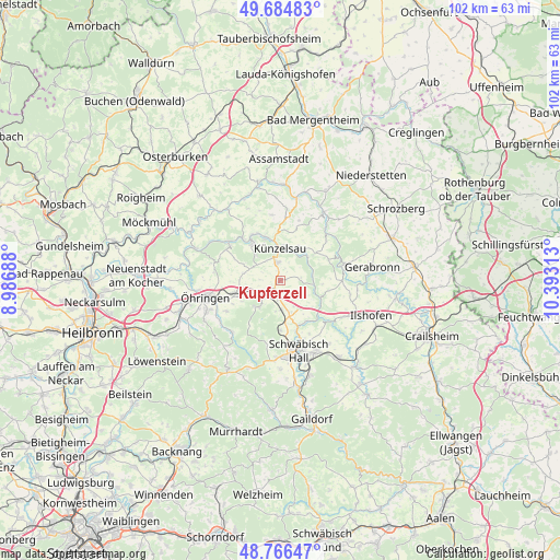
Kupferzell GPS coordinates[2]
49° 13' 40.008" North, 9° 41' 24" East
| Map corner | latitude | longitude |
|---|---|---|
| Upper-left | 49.68483°, | 8.98688° |
| Center: | 49.22778°, | 9.69° |
| Lower-right: | 48.76647°, | 10.39313° |
| Map W x H: | 102.1×102.1 km | = 63.4×63.4mi |
| max Lat: | 55.01917° ⇑80% North |
| Kupferzell: | 49.22778° |
| min Lat: | ⇓20% South 47.40724° |
| min Long | Kupferzell | max Long |
| 5.92978° | 9.69° | 14.98853° |
| W 45.5%⇐ | ⇒54.5% E |
Elevation
Elevation of Kupferzell is 333 m = 1093 ft, and this is 83.9 m = 275 ft above average elevation for this country.
| Max E: |
1256 m = 4121 ft | 33.3% |
| Kupferzell | 333 m 1093 ft | |
| Avg. | 249.1 m = 817 ft | |
Min E: |
-5 m = -16 ft | 66.7% |
See also: Germany elevation on elevation.city.
Geographical zone
Kupferzell is located in North temperate zone (between Tropic of Cancer and the Arctic Circle). Distance of this North polar circle is 1927.6 km =1197.8 mi to North.| Distance of | km | miles | from Kupferzell |
|---|---|---|---|
| North Pole | 4533.4 | 2816.9 | to North |
| Arctic Circle | 1927.6 | 1197.8 | to North |
| Tropic Cancer | 2867.7 | 1781.9 | to South |
| Equator | 5473.6 | 3401.1 | to South |


Nearby cities:
15 places around Kupferzell: (largest is in red/bold)
• Braunsbach
8 km =5 mi,  113°
113°
• Forchtenberg
11.6 km =7.2 mi,  305°
305°
• Ingelfingen
8.5 km =5.3 mi,  341°
341°
• Künzelsau
6 km =3.7 mi,  355°
355°
• Langenburg
12.4 km =7.7 mi,  76°
76°
• Michelfeld
14.5 km =9 mi,  183°
183°
• Neuenstein
8.4 km =5.2 mi,  252°
252°
• Niedernhall
9.2 km =5.7 mi,  324°
324°
• Schwäbisch Hall
13.4 km =8.3 mi,  164°
164°
• Untermünkheim
9 km =5.6 mi, 159°
• Waldenburg
6 km =3.7 mi,  217°
217°
• Weißbach
10.3 km =6.4 mi, 318°
• Wolpertshausen
13.1 km =8.1 mi,  120°
120°
• Zweiflingen
12.9 km =8 mi,  284°
284°
• Öhringen
13.7 km =8.5 mi,  256°
256°
Sources, notices
• [Note1] Compared only with cities in Germany existing in our database
• [Src1] Map data: © OpenStreetMap contributors (CC-BY-SA)
• [Src2] Other city data from geonames.org with taken over terms of usage.
• [Src3] Geographical zone / Annual Mean Temperature by Robert A. Rohde @ Wikipedia
