Blaubeuren geodata
Blaubeuren (Baden-Württemberg) is a populated place; located in Germany in Europe/Berlin (GMT+2) time zone. With population of 11,797 people, there are 1391 cities with bigger population in this country. Compared to other cities in Germany, 90.1% of cities are located further ↑North; 53% of cities are located further →East and 90.5% of cities have lower elevation than Blaubeuren. Note1
Administrative division(s):
- Level 1: Baden-Württemberg
- Level 2: Tübingen Region
- Level 3: Alb-Donau-Kreis
- Level 4: Blaubeuren


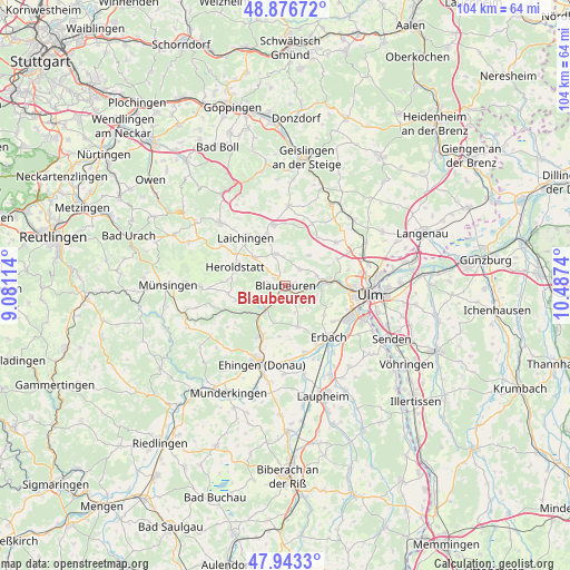
Blaubeuren GPS coordinates[2]
48° 24' 43.74" North, 9° 47' 3.372" East
| Map corner | latitude | longitude |
|---|---|---|
| Upper-left | 48.87672°, | 9.08114° |
| Center: | 48.41215°, | 9.78427° |
| Lower-right: | 47.9433°, | 10.4874° |
| Map W x H: | 103.8×103.8 km | = 64.5×64.5mi |
| max Lat: | 55.01917° ⇑90.1% North |
| Blaubeuren: | 48.41215° |
| min Lat: | ⇓9.9% South 47.40724° |
| min Long | Blaubeuren | max Long |
| 5.92978° | 9.78427° | 14.98853° |
| W 47%⇐ | ⇒53% E |
Elevation
Elevation of Blaubeuren is 520 m = 1706 ft, and this is 270.9 m = 889 ft above average elevation for this country.
| Max E: |
1256 m = 4121 ft | 9.5% |
| Blaubeuren | 520 m 1706 ft | |
| Avg. | 249.1 m = 817 ft | |
Min E: |
-5 m = -16 ft | 90.5% |
See also: Germany elevation on elevation.city.
Geographical zone
Blaubeuren is located in North temperate zone (between Tropic of Cancer and the Arctic Circle). Distance of this North polar circle is 2018.2 km =1254.1 mi to North.| Distance of | km | miles | from Blaubeuren |
|---|---|---|---|
| North Pole | 4624.1 | 2873.3 | to North |
| Arctic Circle | 2018.2 | 1254.1 | to North |
| Tropic Cancer | 2777 | 1725.5 | to South |
| Equator | 5382.9 | 3344.8 | to South |


Nearby cities:
15 places around Blaubeuren: (largest is in red/bold)
• Allmendingen
10.1 km =6.3 mi,  206°
206°
• Altheim
9.4 km =5.8 mi,  186°
186°
• Berghülen
6 km =3.7 mi,  343°
343°
• Blaustein
9.8 km =6.1 mi,  87°
87°
• Dornstadt
13.3 km =8.3 mi,  62°
62°
• Ehingen
15 km =9.3 mi,  196°
196°
• Erbach
12 km =7.5 mi,  140°
140°
• Ersingen
14.3 km =8.9 mi,  158°
158°
• Klingenstein
9.2 km =5.7 mi, 85°
• Laichingen
11.2 km =7 mi,  319°
319°
• Merklingen
11.2 km =7 mi,  348°
348°
• Nellingen
14.4 km =8.9 mi,  1°
1°
• Oberdischingen
13 km =8.1 mi, 163°
• Schelklingen
5.6 km =3.5 mi,  223°
223°
• Öpfingen
14.1 km =8.8 mi,  174°
174°
Sources, notices
• [Note1] Compared only with cities in Germany existing in our database
• [Src1] Map data: © OpenStreetMap contributors (CC-BY-SA)
• [Src2] Other city data from geonames.org with taken over terms of usage.
• [Src3] Geographical zone / Annual Mean Temperature by Robert A. Rohde @ Wikipedia
