Laar geodata
Laar (Lower Saxony) is a populated place; located in Germany in Europe/Berlin (GMT+2) time zone. With population of 2,193 people, there are 4810 cities with bigger population in this country. Compared to other cities in Germany, 75.8% of cities are located further ↓South; 73.4% of cities are located further →East and 79.4% of cities have higher elevation than Laar. Note1


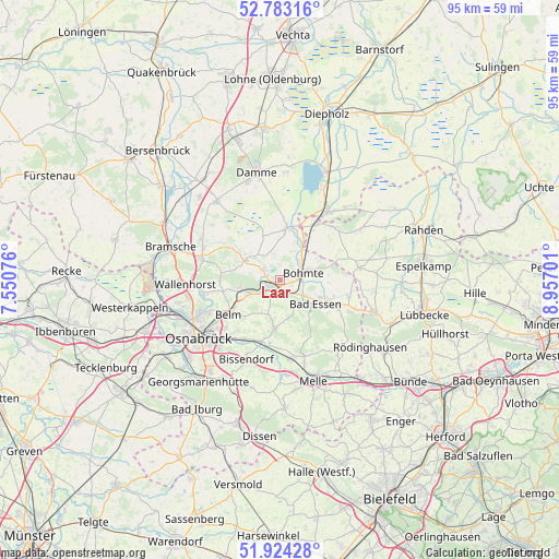
Laar GPS coordinates[2]
52° 21' 20.916" North, 8° 15' 13.968" East
| Map corner | latitude | longitude |
|---|---|---|
| Upper-left | 52.78316°, | 7.55076° |
| Center: | 52.35581°, | 8.25388° |
| Lower-right: | 51.92428°, | 8.95701° |
| Map W x H: | 95.5×95.5 km | = 59.3×59.3mi |
| max Lat: | 55.01917° ⇑24.2% North |
| Laar: | 52.35581° |
| min Lat: | ⇓75.8% South 47.40724° |
| min Long | Laar | max Long |
| 5.92978° | 8.25388° | 14.98853° |
| W 26.6%⇐ | ⇒73.4% E |
Elevation
Elevation of Laar is 48 m = 157 ft, and this is 201.1 m = 660 ft below average elevation for this country.
| Max E: |
1256 m = 4121 ft | 79.4% |
| Avg. | 249.1 m = 817 ft | |
| Laar | 48 m = 157 ft | |
Min E: |
-5 m = -16 ft | 20.6% |
See also: Germany elevation on elevation.city.
Geographical zone
Laar is located in North temperate zone (between Tropic of Cancer and the Arctic Circle). Distance of this North polar circle is 1579.8 km =981.6 mi to North.| Distance of | km | miles | from Laar |
|---|---|---|---|
| North Pole | 4185.6 | 2600.8 | to North |
| Arctic Circle | 1579.8 | 981.6 | to North |
| Tropic Cancer | 3215.5 | 1998 | to South |
| Equator | 5821.4 | 3617.2 | to South |


Nearby cities:
15 places around Laar: (largest is in red/bold)
• Bad Essen
6.9 km =4.3 mi,  128°
128°
• Belm
10.3 km =6.4 mi,  232°
232°
• Bissendorf
14.9 km =9.3 mi,  203°
203°
• Bohmte
4.4 km =2.7 mi,  74°
74°
• Brockum
16.5 km =10.3 mi,  41°
41°
• Huede
17.1 km =10.6 mi,  24°
24°
• Lemförde
14.8 km =9.2 mi,  34°
34°
• Marl
16.1 km =10 mi, 28°
• Melle
18 km =11.2 mi,  161°
161°
• Osnabrück
16.7 km =10.4 mi,  236°
236°
• Ostercappeln
1.5 km =0.9 mi,  245°
245°
• Preußisch Oldendorf
17.2 km =10.7 mi,  108°
108°
• Quernheim
15.8 km =9.8 mi, 38°
• Stemshorn
13 km =8.1 mi, 36°
• Wallenhorst
16.1 km =10 mi,  267°
267°
Sources, notices
• [Note1] Compared only with cities in Germany existing in our database
• [Src1] Map data: © OpenStreetMap contributors (CC-BY-SA)
• [Src2] Other city data from geonames.org with taken over terms of usage.
• [Src3] Geographical zone / Annual Mean Temperature by Robert A. Rohde @ Wikipedia
