Belm geodata
Belm (Lower Saxony) is a seat of a fourth-order administrative division; located in Germany in Europe/Berlin (GMT+2) time zone. With population of 13,897 people, there are 1149 cities with bigger population in this country. Compared to other cities in Germany, 75.1% of cities are located further ↓South; 74.9% of cities are located further →East and 70.2% of cities have higher elevation than Belm. Note1


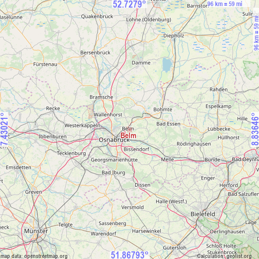
Belm GPS coordinates[2]
52° 18' 0" North, 8° 7' 59.988" East
| Map corner | latitude | longitude |
|---|---|---|
| Upper-left | 52.7279°, | 7.43021° |
| Center: | 52.3°, | 8.13333° |
| Lower-right: | 51.86793°, | 8.83646° |
| Map W x H: | 95.6×95.6 km | = 59.4×59.4mi |
| max Lat: | 55.01917° ⇑24.9% North |
| Belm: | 52.3° |
| min Lat: | ⇓75.1% South 47.40724° |
| min Long | Belm | max Long |
| 5.92978° | 8.13333° | 14.98853° |
| W 25.1%⇐ | ⇒74.9% E |
Elevation
Elevation of Belm is 90 m = 295 ft, and this is 159.1 m = 522 ft below average elevation for this country.
| Max E: |
1256 m = 4121 ft | 70.2% |
| Avg. | 249.1 m = 817 ft | |
| Belm | 90 m = 295 ft | |
Min E: |
-5 m = -16 ft | 29.8% |
See also: Germany elevation on elevation.city.
Geographical zone
Belm is located in North temperate zone (between Tropic of Cancer and the Arctic Circle). Distance of this North polar circle is 1586 km =985.5 mi to North.| Distance of | km | miles | from Belm |
|---|---|---|---|
| North Pole | 4191.8 | 2604.7 | to North |
| Arctic Circle | 1586 | 985.5 | to North |
| Tropic Cancer | 3209.3 | 1994.2 | to South |
| Equator | 5815.2 | 3613.4 | to South |


Nearby cities:
15 places around Belm: (largest is in red/bold)
• Bad Essen
13.7 km =8.5 mi,  82°
82°
• Bad Iburg
17.3 km =10.7 mi,  201°
201°
• Bissendorf
7.8 km =4.8 mi,  162°
162°
• Bohmte
14.5 km =9 mi,  59°
59°
• Bramsche
16.3 km =10.1 mi,  317°
317°
• Georgsmarienhütte
12.4 km =7.7 mi,  209°
209°
• Hagen
15.5 km =9.6 mi,  222°
222°
• Hasbergen
13.6 km =8.5 mi,  239°
239°
• Laar
10.3 km =6.4 mi,  52°
52°
• Lotte
14.9 km =9.3 mi,  262°
262°
• Melle
17.7 km =11 mi,  128°
128°
• Osnabrück
6.4 km =4 mi, 241°
• Ostercappeln
8.8 km =5.5 mi, 50°
• Wallenhorst
9.7 km =6 mi,  305°
305°
• Westerkappeln
17.1 km =10.6 mi,  276°
276°
Sources, notices
• [Note1] Compared only with cities in Germany existing in our database
• [Src1] Map data: © OpenStreetMap contributors (CC-BY-SA)
• [Src2] Other city data from geonames.org with taken over terms of usage.
• [Src3] Geographical zone / Annual Mean Temperature by Robert A. Rohde @ Wikipedia
