Wallenhorst geodata
Wallenhorst (Lower Saxony) is a seat of a fourth-order administrative division; located in Germany in Europe/Berlin (GMT+2) time zone. With population of 24,201 people, there are 617 cities with bigger population in this country. Compared to other cities in Germany, 75.7% of cities are located further ↓South; 76.8% of cities are located further →East and 69.2% of cities have higher elevation than Wallenhorst. Note1


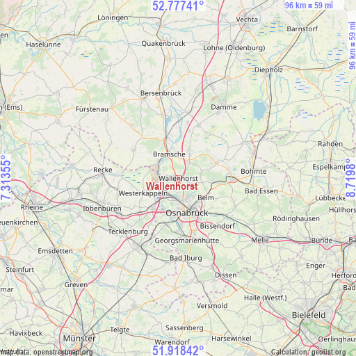
Wallenhorst GPS coordinates[2]
52° 21' 0" North, 8° 1' 0.012" East
| Map corner | latitude | longitude |
|---|---|---|
| Upper-left | 52.77741°, | 7.31355° |
| Center: | 52.35°, | 8.01667° |
| Lower-right: | 51.91842°, | 8.7198° |
| Map W x H: | 95.5×95.5 km | = 59.3×59.3mi |
| max Lat: | 55.01917° ⇑24.3% North |
| Wallenhorst: | 52.35° |
| min Lat: | ⇓75.7% South 47.40724° |
| min Long | Wallenhorst | max Long |
| 5.92978° | 8.01667° | 14.98853° |
| W 23.2%⇐ | ⇒76.8% E |
Elevation
Elevation of Wallenhorst is 96 m = 315 ft, and this is 153.1 m = 502 ft below average elevation for this country.
| Max E: |
1256 m = 4121 ft | 69.2% |
| Avg. | 249.1 m = 817 ft | |
| Wallenhorst | 96 m = 315 ft | |
Min E: |
-5 m = -16 ft | 30.8% |
See also: Germany elevation on elevation.city.
Geographical zone
Wallenhorst is located in North temperate zone (between Tropic of Cancer and the Arctic Circle). Distance of this North polar circle is 1580.4 km =982 mi to North.| Distance of | km | miles | from Wallenhorst |
|---|---|---|---|
| North Pole | 4186.3 | 2601.2 | to North |
| Arctic Circle | 1580.4 | 982 | to North |
| Tropic Cancer | 3214.9 | 1997.6 | to South |
| Equator | 5820.8 | 3616.9 | to South |


Nearby cities:
15 places around Wallenhorst: (largest is in red/bold)
• Alfhausen
17.3 km =10.7 mi,  344°
344°
• Belm
9.7 km =6 mi,  125°
125°
• Bissendorf
16.5 km =10.3 mi,  141°
141°
• Bramsche
7.2 km =4.5 mi, 335°
• Georgsmarienhütte
16.5 km =10.3 mi,  173°
173°
• Hagen
17.3 km =10.7 mi,  188°
188°
• Hasbergen
13.1 km =8.1 mi,  196°
196°
• Laar
16.1 km =10 mi,  87°
87°
• Lotte
10.1 km =6.3 mi,  222°
222°
• Mettingen
16.3 km =10.1 mi,  256°
256°
• Neuenkirchen
14.2 km =8.8 mi,  301°
301°
• Osnabrück
8.9 km =5.5 mi, 165°
• Ostercappeln
14.7 km =9.1 mi, 90°
• Rieste
14.8 km =9.2 mi,  0°
0°
• Westerkappeln
9.8 km =6.1 mi,  247°
247°
Sources, notices
• [Note1] Compared only with cities in Germany existing in our database
• [Src1] Map data: © OpenStreetMap contributors (CC-BY-SA)
• [Src2] Other city data from geonames.org with taken over terms of usage.
• [Src3] Geographical zone / Annual Mean Temperature by Robert A. Rohde @ Wikipedia
