Kraichtal geodata
Kraichtal (Baden-Württemberg) is a seat of a fourth-order administrative division; located in Germany in Europe/Berlin (GMT+2) time zone. With population of 14,416 people, there are 1097 cities with bigger population in this country. Compared to other cities in Germany, 81.2% of cities are located further ↑North; 68.8% of cities are located further →East and 51% of cities have higher elevation than Kraichtal. Note1
Administrative division(s):
- Level 1: Baden-Württemberg
- Level 2: Karlsruhe Region
- Level 3: Landkreis Karlsruhe
- Level 4: Kraichtal


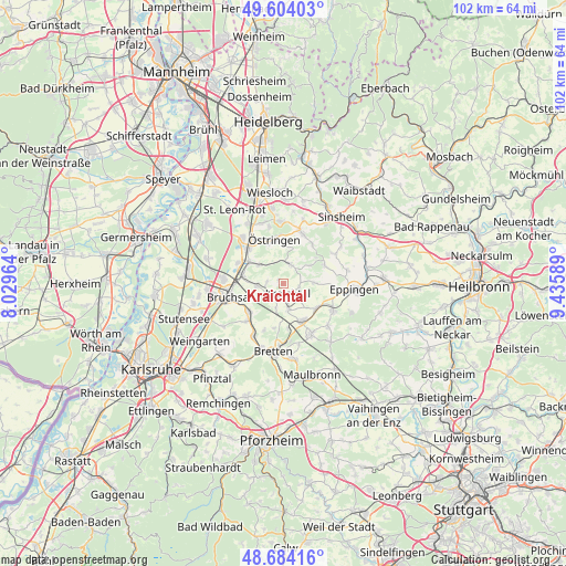
Kraichtal GPS coordinates[2]
49° 8' 46.428" North, 8° 43' 57.936" East
| Map corner | latitude | longitude |
|---|---|---|
| Upper-left | 49.60403°, | 8.02964° |
| Center: | 49.14623°, | 8.73276° |
| Lower-right: | 48.68416°, | 9.43589° |
| Map W x H: | 102.3×102.3 km | = 63.6×63.6mi |
| max Lat: | 55.01917° ⇑81.2% North |
| Kraichtal: | 49.14623° |
| min Lat: | ⇓18.8% South 47.40724° |
| min Long | Kraichtal | max Long |
| 5.92978° | 8.73276° | 14.98853° |
| W 31.2%⇐ | ⇒68.8% E |
Elevation
Elevation of Kraichtal is 218 m = 715 ft, and this is 31.1 m = 102 ft below average elevation for this country.
| Max E: |
1256 m = 4121 ft | 51% |
| Avg. | 249.1 m = 817 ft | |
| Kraichtal | 218 m = 715 ft | |
Min E: |
-5 m = -16 ft | 49% |
See also: Germany elevation on elevation.city.
Geographical zone
Kraichtal is located in North temperate zone (between Tropic of Cancer and the Arctic Circle). Distance of this North polar circle is 1936.6 km =1203.3 mi to North.| Distance of | km | miles | from Kraichtal |
|---|---|---|---|
| North Pole | 4542.5 | 2822.6 | to North |
| Arctic Circle | 1936.6 | 1203.3 | to North |
| Tropic Cancer | 2858.6 | 1776.3 | to South |
| Equator | 5464.5 | 3395.5 | to South |


Nearby cities:
15 places around Kraichtal: (largest is in red/bold)
• Bretten
12.3 km =7.6 mi,  188°
188°
• Bruchsal
10.1 km =6.3 mi,  256°
256°
• Eppingen
13.1 km =8.1 mi,  94°
94°
• Forst
11.1 km =6.9 mi,  277°
277°
• Gondelsheim
11.1 km =6.9 mi,  209°
209°
• Kronau
11.2 km =7 mi,  318°
318°
• Kürnbach
11.2 km =7 mi,  132°
132°
• Malsch
11.8 km =7.3 mi,  342°
342°
• Mühlhausen
11.4 km =7.1 mi,  357°
357°
• Oberderdingen
10.3 km =6.4 mi,  150°
150°
• Sternenfels
13.6 km =8.5 mi,  140°
140°
• Sulzfeld
10.1 km =6.3 mi,  117°
117°
• Ubstadt-Weiher
7.6 km =4.7 mi, 284°
• Zaisenhausen
7.3 km =4.5 mi, 127°
• Östringen
8.2 km =5.1 mi,  349°
349°
Sources, notices
• [Note1] Compared only with cities in Germany existing in our database
• [Src1] Map data: © OpenStreetMap contributors (CC-BY-SA)
• [Src2] Other city data from geonames.org with taken over terms of usage.
• [Src3] Geographical zone / Annual Mean Temperature by Robert A. Rohde @ Wikipedia
