Kunrau geodata
Kunrau (Saxony-Anhalt) is a populated place; located in Germany in Europe/Berlin (GMT+2) time zone. With population of 921 people, there are 7452 cities with bigger population in this country. Compared to other cities in Germany, 78.3% of cities are located further ↓South; 67.3% of cities are located further ←West and 75% of cities have higher elevation than Kunrau. Note1


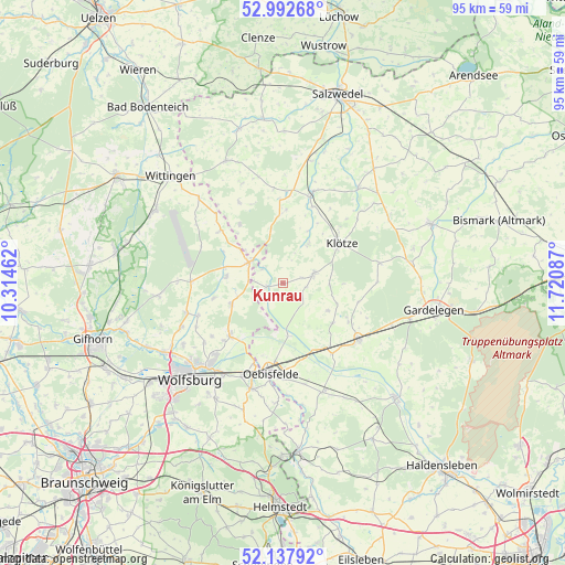
Kunrau GPS coordinates[2]
52° 34' 2.568" North, 11° 1' 3.864" East
| Map corner | latitude | longitude |
|---|---|---|
| Upper-left | 52.99268°, | 10.31462° |
| Center: | 52.56738°, | 11.01774° |
| Lower-right: | 52.13792°, | 11.72087° |
| Map W x H: | 95×95 km | = 59×59mi |
| max Lat: | 55.01917° ⇑21.7% North |
| Kunrau: | 52.56738° |
| min Lat: | ⇓78.3% South 47.40724° |
| min Long | Kunrau | max Long |
| 5.92978° | 11.01774° | 14.98853° |
| W 67.3%⇐ | ⇒32.7% E |
Elevation
Elevation of Kunrau is 63 m = 207 ft, and this is 186.1 m = 611 ft below average elevation for this country.
| Max E: |
1256 m = 4121 ft | 75% |
| Avg. | 249.1 m = 817 ft | |
| Kunrau | 63 m = 207 ft | |
Min E: |
-5 m = -16 ft | 25% |
See also: Germany elevation on elevation.city.
Geographical zone
Kunrau is located in North temperate zone (between Tropic of Cancer and the Arctic Circle). Distance of this North polar circle is 1556.2 km =967 mi to North.| Distance of | km | miles | from Kunrau |
|---|---|---|---|
| North Pole | 4162.1 | 2586.2 | to North |
| Arctic Circle | 1556.2 | 967 | to North |
| Tropic Cancer | 3239 | 2012.6 | to South |
| Equator | 5844.9 | 3631.9 | to South |


Nearby cities:
15 places around Kunrau: (largest is in red/bold)
• Bandau
13.2 km =8.2 mi,  28°
28°
• Bergfeld
12 km =7.5 mi,  257°
257°
• Brome
6.5 km =4 mi,  303°
303°
• Grafhorst
14.5 km =9 mi,  199°
199°
• Immekath
7.8 km =4.8 mi, 33°
• Jahrstedt
2.9 km =1.8 mi,  253°
253°
• Jübar
15.4 km =9.6 mi,  331°
331°
• Klötze
11.9 km =7.4 mi,  56°
56°
• Kusey
5.1 km =3.2 mi,  74°
74°
• Miesterhorst
14.5 km =9 mi,  144°
144°
• Oebisfelde
14.9 km =9.3 mi,  187°
187°
• Parsau
9.4 km =5.8 mi, 247°
• Rühen
12.7 km =7.9 mi,  224°
224°
• Tülau
9.5 km =5.9 mi,  275°
275°
• Wenze
7.8 km =4.8 mi,  92°
92°
Sources, notices
• [Note1] Compared only with cities in Germany existing in our database
• [Src1] Map data: © OpenStreetMap contributors (CC-BY-SA)
• [Src2] Other city data from geonames.org with taken over terms of usage.
• [Src3] Geographical zone / Annual Mean Temperature by Robert A. Rohde @ Wikipedia
