Jübar geodata
Jübar (Saxony-Anhalt) is a seat of a fourth-order administrative division; located in Germany in Europe/Berlin (GMT+2) time zone. With population of 690 people, there are 8362 cities with bigger population in this country. Compared to other cities in Germany, 79.6% of cities are located further ↓South; 65.6% of cities are located further ←West and 70.4% of cities have higher elevation than Jübar. Note1


Jübar GPS coordinates[2]
52° 41' 20.544" North, 10° 54' 32.328" East
| Map corner | latitude | longitude |
|---|---|---|
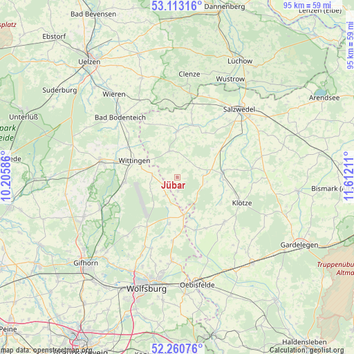
| Upper-left | 53.11316°, | 10.20586° |
| Center: | 52.68904°, | 10.90898° |
| Lower-right: | 52.26076°, | 11.61211° |
| Map W x H: | 94.8×94.8 km | = 58.9×58.9mi |
| max Lat: | 55.01917° ⇑20.4% North |
| Jübar: | 52.68904° |
| min Lat: | ⇓79.6% South 47.40724° |
| min Long | Jübar | max Long |
| 5.92978° | 10.90898° | 14.98853° |
| W 65.6%⇐ | ⇒34.4% E |
Elevation
Elevation of Jübar is 89 m = 292 ft, and this is 160.1 m = 525 ft below average elevation for this country.
| Max E: |
1256 m = 4121 ft | 70.4% |
| Avg. | 249.1 m = 817 ft | |
| Jübar | 89 m = 292 ft | |
Min E: |
-5 m = -16 ft | 29.6% |
See also: Germany elevation on elevation.city.
Geographical zone
Jübar is located in North temperate zone (between Tropic of Cancer and the Arctic Circle). Distance of this North polar circle is 1542.7 km =958.6 mi to North.| Distance of | km | miles | from Jübar |
|---|---|---|---|
| North Pole | 4148.6 | 2577.8 | to North |
| Arctic Circle | 1542.7 | 958.6 | to North |
| Tropic Cancer | 3252.6 | 2021.1 | to South |
| Equator | 5858.5 | 3640.3 | to South |


Nearby cities:
15 places around Jübar: (largest is in red/bold)
• Bandau
13.7 km =8.5 mi,  98°
98°
• Beetzendorf
12.2 km =7.6 mi,  83°
83°
• Bergfeld
16.7 km =10.4 mi,  194°
194°
• Brome
10.1 km =6.3 mi,  168°
168°
• Dähre
12.1 km =7.5 mi,  359°
359°
• Henningen
17.5 km =10.9 mi,  12°
12°
• Immekath
13.6 km =8.5 mi,  121°
121°
• Jahrstedt
15.1 km =9.4 mi,  162°
162°
• Kunrau
15.4 km =9.6 mi,  151°
151°
• Kusey
17.2 km =10.7 mi,  134°
134°
• Parsau
17.2 km =10.7 mi,  184°
184°
• Rohrberg
9.1 km =5.7 mi, 76°
• Tülau
12.8 km =8 mi, 189°
• Wallstawe
14.3 km =8.9 mi,  30°
30°
• Wittingen
12.4 km =7.7 mi,  289°
289°
Sources, notices
• [Note1] Compared only with cities in Germany existing in our database
• [Src1] Map data: © OpenStreetMap contributors (CC-BY-SA)
• [Src2] Other city data from geonames.org with taken over terms of usage.
• [Src3] Geographical zone / Annual Mean Temperature by Robert A. Rohde @ Wikipedia
